
Yawn! I feel like it's time to come out of hibernation!
Anyone seen any positive indicating that this winter will bring on feet of snow instead of inches?! I'll have a little snoop online for long-term (i.e. highly inaccurate!) forecasts later, but so far I'm hoping that a massive number of wasps, ladybirds and wallabies locally are all good signs!
https://www.bbc.co.uk/news/articles/cz7 ... =deep-link
https://www.bbc.co.uk/news/articles/c14 ... =deep-link
https://www.bbc.co.uk/news/articles/cj0 ... =deep-link
I'm also pretty adamant that this year is a 'mast year' - something I've only learnt about recently after trying to find out why there were so many apples, pears, plums, conkers and nuts forming on the trees. Chat GPT says there might be a link (but correlation does not mean causation!)
Either way, it's nice to be back and I hoped your all well!
Winter 25/26 Early Signs
-
makelikeaturkey
- Posts: 72
- Joined: Sat Oct 05, 2024 5:05 pm
- Location: NG12
- Has thanked: 114 times
- Been thanked: 55 times
-
Andee

- UKWW Admin
- Posts: 502
- Joined: Thu Oct 03, 2024 4:21 pm
- Location: Mevagissey
- Has thanked: 252 times
- Been thanked: 144 times
Re: Winter 25/26 Early Signs
Welcome back, Mike
They say when the fruit trees are bursting, a beast of a winter’s brewing. Just an old wives’ tale… but those old wives knew things, didn’t they?
Still, we’re well overdue a proper snowstorm, bring it on! And when everything grinds to a halt, we’ll just nod wisely and say, “Ah yes… global warming.”
They say when the fruit trees are bursting, a beast of a winter’s brewing. Just an old wives’ tale… but those old wives knew things, didn’t they?
Still, we’re well overdue a proper snowstorm, bring it on! And when everything grinds to a halt, we’ll just nod wisely and say, “Ah yes… global warming.”

Keep up to date on our Facebook Group
https://www.facebook.com/groups/ukweatherwatch.co.uk
https://www.facebook.com/groups/ukweatherwatch.co.uk
-
KTtom
- UKWW Admin
- Posts: 462
- Joined: Fri Oct 04, 2024 7:12 pm
- Has thanked: 117 times
- Been thanked: 551 times
Re: Winter 25/26 Early Signs
Some of the key driver for our longer term prospects beginning to come into play. Firstly, a disclaimer, I'm not a fantastic believer of teleconnections, yes they drive our weather but there are just so many that if one doesn't play ball it seems to over-ride the direction of travel and knock everything off track. Anyway, the National Climate centre have publicised their observations of a La Nina conditions (colder sea surface temperatures) in the central Pacific which are forecast to remain in place into next year.
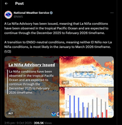
Traditionally warmer SST's fuel a strong jet through America and out into the Atlantic, resulting in an onslaught of Atlantic systems for the UK. The opposite and we have a weaker jet which meanders west to east allowing high pressure to form at higher latitudes than would normally be the case, this has a knock on effect on the polor vortex also being weaker, increasing the chances of colder and quieter weather for the UK and Europe.Interesting to see how this progresses during November. At the moment though indications are for a more blocked pattern December and January with a wet and windy February.
Traditionally warmer SST's fuel a strong jet through America and out into the Atlantic, resulting in an onslaught of Atlantic systems for the UK. The opposite and we have a weaker jet which meanders west to east allowing high pressure to form at higher latitudes than would normally be the case, this has a knock on effect on the polor vortex also being weaker, increasing the chances of colder and quieter weather for the UK and Europe.Interesting to see how this progresses during November. At the moment though indications are for a more blocked pattern December and January with a wet and windy February.
-
GarbageBags
- Posts: 86
- Joined: Wed Dec 04, 2024 3:54 pm
- Has thanked: 34 times
- Been thanked: 85 times
Re: Winter 25/26 Early Signs
Hi folks! Starting to get excited about winter. we are WELL overdue a crisp cold / snowy one! I've got 6 chickens now outside in a big run so I've got that all winter ready. Just waiting some lovely frosts now! I'll try to keep dropping in and will hope to post some hype charts in the hype chart section.

-
Andee
- UKWW Admin
- Posts: 502
- Joined: Thu Oct 03, 2024 4:21 pm
- Location: Mevagissey
- Has thanked: 252 times
- Been thanked: 144 times
Re: Winter 25/26 Early Signs
Good to have you back and look forward to the hype charts.
Keep up to date on our Facebook Group
https://www.facebook.com/groups/ukweatherwatch.co.uk
https://www.facebook.com/groups/ukweatherwatch.co.uk
-
KTtom
- UKWW Admin
- Posts: 462
- Joined: Fri Oct 04, 2024 7:12 pm
- Has thanked: 117 times
- Been thanked: 551 times
Re: Winter 25/26 Early Signs
Met office longer term outlook hinting at a pattern change by the end of the month, as hinted at the weak La nina signal posted above..
"Unsettled conditions will probably be dominant across the UK at first, with showers or longer spells of rain for many areas and a risk of strong winds. Temperatures are expected to be around normal. During the second half of November, the most probable outcome is for increasing amounts of dry and fine weather, although with some overnight fog and frost. Any wetter spells are most likely to affect the north of the UK."
Updated: 15:00 (UTC) on Mon 27 Oct 2025
-
makelikeaturkey
- Posts: 72
- Joined: Sat Oct 05, 2024 5:05 pm
- Location: NG12
- Has thanked: 114 times
- Been thanked: 55 times
Re: Winter 25/26 Early Signs
Cold and wet?! Keep us posted! 
KTtom wrote: Mon Oct 27, 2025 7:03 pm Met office longer term outlook hinting at a pattern change by the end of the month, as hinted at the weak La nina signal posted above..
"Unsettled conditions will probably be dominant across the UK at first, with showers or longer spells of rain for many areas and a risk of strong winds. Temperatures are expected to be around normal. During the second half of November, the most probable outcome is for increasing amounts of dry and fine weather, although with some overnight fog and frost. Any wetter spells are most likely to affect the north of the UK."
Updated: 15:00 (UTC) on Mon 27 Oct 2025
-
KTtom
- UKWW Admin
- Posts: 462
- Joined: Fri Oct 04, 2024 7:12 pm
- Has thanked: 117 times
- Been thanked: 551 times
Re: Winter 25/26 Early Signs
Not looking good for the early skiing in europe...this is quite a shocking upper air temperature chart for 5th November... Scandinavis should be sub zero by now with a good snow cover....everywhere even the Arctic is several degrees warmer than where it should be.
A glimmer of light as we head mid month is the UK high ive posted on the other thread, this will draw down the arctic air into Scandinavia.
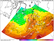
A glimmer of light as we head mid month is the UK high ive posted on the other thread, this will draw down the arctic air into Scandinavia.