Warnings Issued — 2 YELLOW
Autumn/Winter Model Outlook 2025/26
-
KTtom
- UKWW Admin
- Posts: 477
- Joined: Fri Oct 04, 2024 7:12 pm
- Has thanked: 119 times
- Been thanked: 568 times
Re: Autumn / Winter Model Outlook
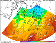
High presssure prospects delayed somewhat... this week is looming particularly mild, wet and gloomy as south to sputh westerly winds dominate with a succession of wether fronts embedded in the flow...fax for Wednesday sums the week up...
-
KTtom
- UKWW Admin
- Posts: 477
- Joined: Fri Oct 04, 2024 7:12 pm
- Has thanked: 119 times
- Been thanked: 568 times
Re: Autumn / Winter Model Outlook
Looking a bit further afield, day 7 and Scandinavia due to have its first sub zero blast of the season... Itll be worth keeping an eye on the Levi and Ruka web cams this time next week.
-
KTtom
- UKWW Admin
- Posts: 477
- Joined: Fri Oct 04, 2024 7:12 pm
- Has thanked: 119 times
- Been thanked: 568 times
Re: Autumn / Winter Model Outlook
Not worth dusting the sledges off quite yet, but both longer term models (gfs and ecm) shwing the holy grail of a 'cut off Greenland high ' for mid month. This pulls the cold arctic air south..not as far a the UK at this stage but a good building block for a 2010 type start to winter...
-
GarbageBags
- Posts: 86
- Joined: Wed Dec 04, 2024 3:54 pm
- Has thanked: 34 times
- Been thanked: 85 times
Re: Autumn / Winter Model Outlook
Seeing lots of North Atlantic ridging in the models. Winds from the NE on the way?

-
KTtom
- UKWW Admin
- Posts: 477
- Joined: Fri Oct 04, 2024 7:12 pm
- Has thanked: 119 times
- Been thanked: 568 times
Re: Autumn / Winter Model Outlook
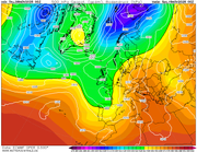
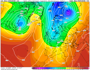
Close but not quite at day 5...following the lines you can see a very potent northerly trying to make it to the UK via a high / low combination to our north, however the azores low pushes the colser air into the Atlantic, although Scotland may well tap in....GarbageBags wrote: Sat Nov 08, 2025 5:28 pm Seeing lots of North Atlantic ridging in the models. Winds from the NE on the way?
Further down the line its all up in the air, so to speak, but the ingredients are there for an early season northerly.
This is a cracking chart (day 7) if it were mid-winter!
-
makelikeaturkey
- Posts: 72
- Joined: Sat Oct 05, 2024 5:05 pm
- Location: NG12
- Has thanked: 114 times
- Been thanked: 55 times
Re: Autumn / Winter Model Outlook
You have a choice! You can either stay excited all winter, but accept regular disappointment, or wait until it's 24 hours away and (even then, hopefully!) start lamppost watching. I prefer the former but each to their own!Looosy wrote: Wed Nov 12, 2025 12:15 pm I know it's too far out, but GFS and GEM seem to have snow in the South next week...when can I get excited?
-
KTtom
- UKWW Admin
- Posts: 477
- Joined: Fri Oct 04, 2024 7:12 pm
- Has thanked: 119 times
- Been thanked: 568 times
Re: Autumn / Winter Model Outlook
January!Looosy wrote: Wed Nov 12, 2025 12:15 pm I know it's too far out, but GFS and GEM seem to have snow in the South next week...when can I get excited?
Not saying its impossible, but you really need all the jigsaw puzzzles falling into place at once to get lowland snow in the south. Take into CC and its even more difficult. I used to start getting excited at the start of December...now its really mid December before I start taking cold charts seriously.
Having said that...tonights ecm is a cracking chart!
-
GarbageBags
- Posts: 86
- Joined: Wed Dec 04, 2024 3:54 pm
- Has thanked: 34 times
- Been thanked: 85 times
Re: Autumn / Winter Model Outlook
Oh wow. Let's pray get that chart down inside 5 daysKTtom wrote: Wed Nov 12, 2025 6:05 pmJanuary!Looosy wrote: Wed Nov 12, 2025 12:15 pm I know it's too far out, but GFS and GEM seem to have snow in the South next week...when can I get excited?
Not saying its impossible, but you really need all the jigsaw puzzzles falling into place at once to get lowland snow in the south. Take into CC and its even more difficult. I used to start getting excited at the start of December...now its really mid December before I start taking cold charts seriously.
Having said that...tonights ecm is a cracking chart!

-
Andee

- UKWW Admin
- Posts: 508
- Joined: Thu Oct 03, 2024 4:21 pm
- Location: Mevagissey
- Has thanked: 263 times
- Been thanked: 145 times
Re: Autumn / Winter Model Outlook
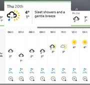
BBC Weather is forecasting light snow for us next Thurs morning.
Keep up to date on our Facebook Group
https://www.facebook.com/groups/ukweatherwatch.co.uk
https://www.facebook.com/groups/ukweatherwatch.co.uk
-
KTtom
- UKWW Admin
- Posts: 477
- Joined: Fri Oct 04, 2024 7:12 pm
- Has thanked: 119 times
- Been thanked: 568 times
Re: Autumn / Winter Model Outlook
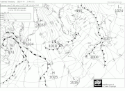
Fax chart for mid week shows a small sysrem moving south in the cold flow. Could bring some early surprises as both upper air and thickness lines are marginal for snow almost anywhere...colder air briefly follows with wintry showers and perhaps some back edge snow as the system clears . Milder again by the weekend.
-
KTtom
- UKWW Admin
- Posts: 477
- Joined: Fri Oct 04, 2024 7:12 pm
- Has thanked: 119 times
- Been thanked: 568 times
Re: Autumn / Winter Model Outlook
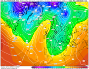
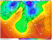
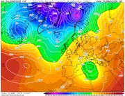
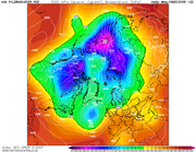
Very rare the Strat gets a mention this early in the season, however an early SSW is on the cards for late November which would make the run up to xmas interesting. The 10hpa chart for late november shows the vortex knocked off its perch and being relocated to Siberia ...
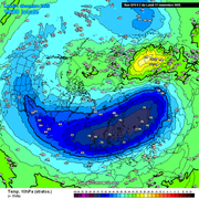
All important stratosphere winds dropping down to negative vales...
All important stratosphere winds dropping down to negative vales...
-
makelikeaturkey
- Posts: 72
- Joined: Sat Oct 05, 2024 5:05 pm
- Location: NG12
- Has thanked: 114 times
- Been thanked: 55 times
Re: Autumn / Winter Model Outlook
And in case you're wondering, here's a good SSW explanation!
https://www.metoffice.gov.uk/blog/2025/ ... ic-warming
https://www.metoffice.gov.uk/blog/2025/ ... ic-warming
-
KTtom
- UKWW Admin
- Posts: 477
- Joined: Fri Oct 04, 2024 7:12 pm
- Has thanked: 119 times
- Been thanked: 568 times
Re: Autumn / Winter Model Outlook
Looking at the model output for next week, its pretty much as you would normally expect at this time of the year, polor vortex really begining to get organised to the north feeding a west to east pattern with the UK in the firing line for mild southwesterlies and wind and rain...
This is where the Strat is needed to help us out, and as posted above, this is still on the cards...the met hinting that we will see the effects of this as the mobile west to east pattern slows and stalls week 2 December...this will be our next window.
This is where the Strat is needed to help us out, and as posted above, this is still on the cards...the met hinting that we will see the effects of this as the mobile west to east pattern slows and stalls week 2 December...this will be our next window.
-
KTtom
- UKWW Admin
- Posts: 477
- Joined: Fri Oct 04, 2024 7:12 pm
- Has thanked: 119 times
- Been thanked: 568 times
Re: Autumn / Winter Model Outlook
Still not much cheer in the model forecast, certainly not much to indicathe the Strat warming is having much impression on the troposphere, best I can find is the last frame of the gfs run...pretty much mild and wet all the way through to the end of week 1 december otherwise!
-
GarbageBags
- Posts: 86
- Joined: Wed Dec 04, 2024 3:54 pm
- Has thanked: 34 times
- Been thanked: 85 times
Re: Autumn / Winter Model Outlook
In your experience - how far out would the models start "taking a SSW seriously"? Like, Do the models take in Strat temp data into account? and I wonder how weighted it is, and at what timescale. Surely no set answers on that stuff, but gets the mind wondering.KTtom wrote: Mon Nov 24, 2025 6:03 am Still not much cheer in the model forecast, certainly not much to indicathe the Strat warming is having much impression on the troposphere, best I can find is the last frame of the gfs run...pretty much mild and wet all the way through to the end of week 1 december otherwise!
-
KTtom
- UKWW Admin
- Posts: 477
- Joined: Fri Oct 04, 2024 7:12 pm
- Has thanked: 119 times
- Been thanked: 568 times
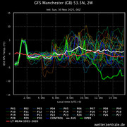
Re: Autumn / Winter Model Outlook
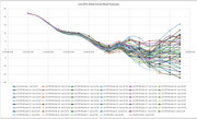
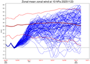
Looking at the latest ECM wind velocity charts, the winds only briefly enter minus territory this weekend before a pretty sharp return to positive vales..the speed of the bounce back may dilute any effects, however anywhere between 10 days and 4 weeks is the general rule for effects of a SSW to filter to the polor vortex. Hopefully we will get a more pronanced warming later in December.
-
KTtom
- UKWW Admin
- Posts: 477
- Joined: Fri Oct 04, 2024 7:12 pm
- Has thanked: 119 times
- Been thanked: 568 times
Re: Autumn / Winter Model Outlook
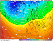
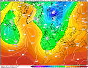
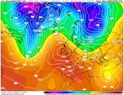
This chart for mid month would sum up our luck...the effects of the SSW can be seen as the PV is disorganised and fragmented, yet a lobe ends up in the mid Atlantic keeping the unsettled conditions going for our neck of the woods! Plenty can change between now and then but this just sums up our luck in winter!
-
GarbageBags
- Posts: 86
- Joined: Wed Dec 04, 2024 3:54 pm
- Has thanked: 34 times
- Been thanked: 85 times
Re: Autumn / Winter Model Outlook
The model run outputs are foul to be honest. Just low after low after low running over the top of us. Could all change as you say!KTtom wrote: Fri Nov 28, 2025 5:14 am This chart for mid month would sum up our luck...the effects of the SSW can be seen as the PV is disorganised and fragmented, yet a lobe ends up in the mid Atlantic keeping the unsettled conditions going for our neck of the woods! Plenty can change between now and then but this just sums up our luck in winter!
-
KTtom
- UKWW Admin
- Posts: 477
- Joined: Fri Oct 04, 2024 7:12 pm
- Has thanked: 119 times
- Been thanked: 568 times
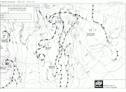
Re: Autumn / Winter Model Outlook
Indeed, GFS operational raised an eyebrow by dishing this chart overnight for the 12th...but checking temperature graph and gfs mean charts clearly show its gone off on a tangent...