
Warnings Issued — 2 YELLOW
Autumn/Winter Model Outlook 2025/26
-
southamptonsnow2010
- Posts: 10
- Joined: Sun Jan 05, 2025 9:04 pm
- Has thanked: 15 times
- Been thanked: 18 times
Re: Autumn / Winter Model Outlook
It wouldn’t be the first time an outlier has gained support? Or maybe I’m just being optimistic 
-
KTtom
- UKWW Admin
- Posts: 477
- Joined: Fri Oct 04, 2024 7:12 pm
- Has thanked: 119 times
- Been thanked: 568 times
Re: Autumn / Winter Model Outlook
...and to be fair, the gfs is still sticking to its guns this morning ... itll have to be well within +300 hrs for me to take seriously tho.southamptonsnow2010 wrote: Sun Nov 30, 2025 9:29 pm It wouldn’t be the first time an outlier has gained support? Or maybe I’m just being optimistic
-
GarbageBags
- Posts: 86
- Joined: Wed Dec 04, 2024 3:54 pm
- Has thanked: 34 times
- Been thanked: 85 times
Re: Autumn / Winter Model Outlook
Hopefully It's early days picking up a pattern changeKTtom wrote: Mon Dec 01, 2025 5:53 am...and to be fair, the gfs is still sticking to its guns this morning ... itll have to be well within +300 hrs for me to take seriously tho.southamptonsnow2010 wrote: Sun Nov 30, 2025 9:29 pm It wouldn’t be the first time an outlier has gained support? Or maybe I’m just being optimistic

-
KTtom
- UKWW Admin
- Posts: 477
- Joined: Fri Oct 04, 2024 7:12 pm
- Has thanked: 119 times
- Been thanked: 568 times
Re: Autumn / Winter Model Outlook
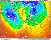
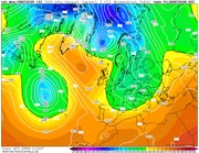
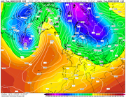
Looking at the mean pressure chart for the 10th and its a poor chart as you could draw up for winter...sadly things are not going to get any better for the next 2 weeks at least.....a tiny hint that high pressure may build in from the south as we head towards Christmas week.
As mentioned on another forum, for us, and most of Europe to be enduring this wet and windy weather when all background signals point to a blocking cold pattern, something has drastically changed!
As mentioned on another forum, for us, and most of Europe to be enduring this wet and windy weather when all background signals point to a blocking cold pattern, something has drastically changed!
-
GarbageBags
- Posts: 86
- Joined: Wed Dec 04, 2024 3:54 pm
- Has thanked: 34 times
- Been thanked: 85 times
Re: Autumn / Winter Model Outlook
I don't think I've ever seen a winter model output as bad as that GFS 06z
-
KTtom
- UKWW Admin
- Posts: 477
- Joined: Fri Oct 04, 2024 7:12 pm
- Has thanked: 119 times
- Been thanked: 568 times
Re: Autumn / Winter Model Outlook
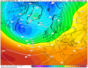
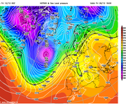
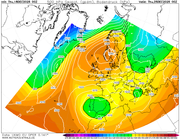
Pffft...check out this mornings...GarbageBags wrote: Thu Dec 04, 2025 11:40 am I don't think I've ever seen a winter model output as bad as that GFS 06z
Forget specifics at this range, just compare the PV to the north west to previous charts posted...as soon as you see the purples over Greenland its a long road to cold....
-
GarbageBags
- Posts: 86
- Joined: Wed Dec 04, 2024 3:54 pm
- Has thanked: 34 times
- Been thanked: 85 times
-
KTtom
- UKWW Admin
- Posts: 477
- Joined: Fri Oct 04, 2024 7:12 pm
- Has thanked: 119 times
- Been thanked: 568 times
Re: Autumn / Winter Model Outlook
No charts, but current feeling is that this wet and windy spell is with us for the next 10 days minimum, it does look likely that the AO will slow in time for the last week in December allowing the CHANCE of a more settled spell, or at least longer, dryer spells between weather systems compared to what we are currently seeing!
-
KTtom
- UKWW Admin
- Posts: 477
- Joined: Fri Oct 04, 2024 7:12 pm
- Has thanked: 119 times
- Been thanked: 568 times
Re: Autumn / Winter Model Outlook
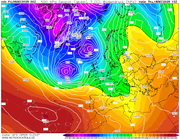
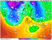
Million miles away, and we have seen these charts for the period around now which never materialised, but tonights Boxing day chart has a nice Atlantic block to finally put a halt to the Atrantic train of lows and allow something colder to move down from the north...KTtom wrote: Wed Dec 10, 2025 6:26 am No charts, but current feeling is that this wet and windy spell is with us for the next 10 days minimum, it does look likely that the AO will slow in time for the last week in December allowing the CHANCE of a more settled spell, or at least longer, dryer spells between weather systems compared to what we are currently seeing!
-
GarbageBags
- Posts: 86
- Joined: Wed Dec 04, 2024 3:54 pm
- Has thanked: 34 times
- Been thanked: 85 times
Re: Autumn / Winter Model Outlook
would be nice! - shame it's in lala land and this mornings run literally the oppositeKTtom wrote: Wed Dec 10, 2025 6:01 pmMillion miles away, and we have seen these charts for the period around now which never materialised, but tonights Boxing day chart has a nice Atlantic block to finally put a halt to the Atrantic train of lows and allow something colder to move down from the north...KTtom wrote: Wed Dec 10, 2025 6:26 am No charts, but current feeling is that this wet and windy spell is with us for the next 10 days minimum, it does look likely that the AO will slow in time for the last week in December allowing the CHANCE of a more settled spell, or at least longer, dryer spells between weather systems compared to what we are currently seeing!
Lets hope something happens long term.
-
Andee

- UKWW Admin
- Posts: 508
- Joined: Thu Oct 03, 2024 4:21 pm
- Location: Mevagissey
- Has thanked: 263 times
- Been thanked: 145 times
Re: Autumn / Winter Model Outlook
This year might be our last ever chance of a white Christmas. We’re moving to Cornwall next year, where the closest thing to snow is a bit of sea foam on a windy day. That said… even living in Yorkshire, I can’t actually remember the last time we had one. So hopes are not exactly sky-high.GarbageBags wrote: Fri Dec 12, 2025 9:02 amwould be nice! - shame it's in lala land and this mornings run literally the oppositeKTtom wrote: Wed Dec 10, 2025 6:01 pmMillion miles away, and we have seen these charts for the period around now which never materialised, but tonights Boxing day chart has a nice Atlantic block to finally put a halt to the Atrantic train of lows and allow something colder to move down from the north...KTtom wrote: Wed Dec 10, 2025 6:26 am No charts, but current feeling is that this wet and windy spell is with us for the next 10 days minimum, it does look likely that the AO will slow in time for the last week in December allowing the CHANCE of a more settled spell, or at least longer, dryer spells between weather systems compared to what we are currently seeing!
Lets hope something happens long term.
Keep up to date on our Facebook Group
https://www.facebook.com/groups/ukweatherwatch.co.uk
https://www.facebook.com/groups/ukweatherwatch.co.uk
-
KTtom
- UKWW Admin
- Posts: 477
- Joined: Fri Oct 04, 2024 7:12 pm
- Has thanked: 119 times
- Been thanked: 568 times
Re: Autumn / Winter Model Outlook
Starting to see some interest in the far, far reaches of the gfs run for late in the month...high pressure looks likely to be over, or very close to the uk. Deep cold to the east...
-
GarbageBags
- Posts: 86
- Joined: Wed Dec 04, 2024 3:54 pm
- Has thanked: 34 times
- Been thanked: 85 times
Re: Autumn / Winter Model Outlook
"PROPER" last white Christmas I remember, with already lying snow (deep and crisp and even!) and falling snow on Christmas day must have been way back in the 90s for me. I remember looking out my bedroom window as a boy one Christmas eve night and there was glistening lying snow in the bright moon light it was magical.Andee wrote: Fri Dec 12, 2025 11:13 amThis year might be our last ever chance of a white Christmas. We’re moving to Cornwall next year, where the closest thing to snow is a bit of sea foam on a windy day. That said… even living in Yorkshire, I can’t actually remember the last time we had one. So hopes are not exactly sky-high.GarbageBags wrote: Fri Dec 12, 2025 9:02 amwould be nice! - shame it's in lala land and this mornings run literally the oppositeKTtom wrote: Wed Dec 10, 2025 6:01 pm
Million miles away, and we have seen these charts for the period around now which never materialised, but tonights Boxing day chart has a nice Atlantic block to finally put a halt to the Atrantic train of lows and allow something colder to move down from the north...
Lets hope something happens long term.
-
KTtom
- UKWW Admin
- Posts: 477
- Joined: Fri Oct 04, 2024 7:12 pm
- Has thanked: 119 times
- Been thanked: 568 times
Re: Autumn / Winter Model Outlook
2010 here, remember going for a drive to see the frozen waterfall nearby on boxing day, it was minus 17 which is unprecidented around here.GarbageBags wrote: Sat Dec 13, 2025 10:31 pm
"PROPER" last white Christmas I remember, with already lying snow (deep and crisp and even!) and falling snow on Christmas day must have been way back in the 90s for me. I remember looking out my bedroom window as a boy one Christmas eve night and there was glistening lying snow in the bright moon light it was magical.
At least the trend at the moment is dryer for the xmas period which is a bonus at the moment!
-
GarbageBags
- Posts: 86
- Joined: Wed Dec 04, 2024 3:54 pm
- Has thanked: 34 times
- Been thanked: 85 times
Re: Autumn / Winter Model Outlook
I look forward to the "WARMER THAN MORROCO" headlines from the DailyMail.
-
southamptonsnow2010
- Posts: 10
- Joined: Sun Jan 05, 2025 9:04 pm
- Has thanked: 15 times
- Been thanked: 18 times
Re: Autumn / Winter Model Outlook
Ironically most of the headlines that appear on my Facebook are all “-17 ARTIC BLAST TO HIT BRITAIN WITH 20 FEET OF SNOW”……….Alas, I wish
-
KTtom
- UKWW Admin
- Posts: 477
- Joined: Fri Oct 04, 2024 7:12 pm
- Has thanked: 119 times
- Been thanked: 568 times
Re: Autumn / Winter Model Outlook
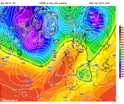
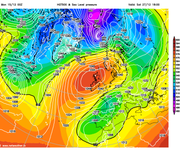
I think we are at the stage now where we can be confident that high pressure will be taking charge around this time next week, centered just to the north of the UK bringing easterly breeze too the south but nothing especially cold, but at least frost should make a comeback in time for christmas...its then a waiting game to see which direction the high shifts to next, its quite common to see it move north west similsr to gfs shows here which leaves the floodgates open from the north...
-
Andee
- UKWW Admin
- Posts: 508
- Joined: Thu Oct 03, 2024 4:21 pm
- Location: Mevagissey
- Has thanked: 263 times
- Been thanked: 145 times
Re: Autumn / Winter Model Outlook
A return of winter 1962/63?southamptonsnow2010 wrote: Mon Dec 15, 2025 8:56 pm Ironically most of the headlines that appear on my Facebook are all “-17 ARTIC BLAST TO HIT BRITAIN WITH 20 FEET OF SNOW”……….Alas, I wish
Keep up to date on our Facebook Group
https://www.facebook.com/groups/ukweatherwatch.co.uk
https://www.facebook.com/groups/ukweatherwatch.co.uk
-
southamptonsnow2010
- Posts: 10
- Joined: Sun Jan 05, 2025 9:04 pm
- Has thanked: 15 times
- Been thanked: 18 times
Re: Autumn / Winter Model Outlook
If the Daily Express have anything to do with it we should be 15 feet buried in snow by now! LolAndee wrote: Tue Dec 16, 2025 8:11 amA return of winter 1962/63?southamptonsnow2010 wrote: Mon Dec 15, 2025 8:56 pm Ironically most of the headlines that appear on my Facebook are all “-17 ARTIC BLAST TO HIT BRITAIN WITH 20 FEET OF SNOW”……….Alas, I wish
-
KTtom
- UKWW Admin
- Posts: 477
- Joined: Fri Oct 04, 2024 7:12 pm
- Has thanked: 119 times
- Been thanked: 568 times
Re: Autumn / Winter Model Outlook
All models now show an easterly of some degree by Christmas day, the main question, is, will the high stay in position long enough to draw the very cold air westwards from Russia...
Here is our very own UKMO models take on xmas eve...
Here is our very own UKMO models take on xmas eve...