UKWeatherWatch is the UK’s leading weather forum – join fellow enthusiasts to discuss forecasts, charts, snow chances, heatwaves, and extreme weather events. Share updates and track storms together.
UKWeatherWatch is the UK’s leading weather forum – join fellow enthusiasts to discuss forecasts, charts, snow chances, heatwaves, and extreme weather events. Share updates and track storms together.
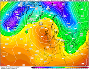
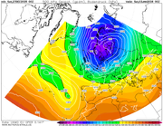
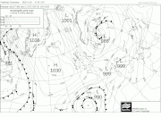
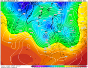
After the Christmas 'easterly' it looks like high presssure takes full control, day 10 gfs below. Plenty of dry frosty weather around. Then we await the area of high pressures next destination, with lower than average pressure over the Med, the sinking of the high allowing mild westerlies back in is seen as a relatively low risk. GFS overnight takes it west and then north west to what many see as the perfect outcome with some very col air to the east waiting to be drawn westwards over the UK...2010 reload!
Not much to add to the above post really. Dry and cold for the next week, we are still looking into the New Year for a possible mid Atlantic ridge, Scandinavian trough combo ... gfs pretty consistant with this even at this timeframe... here is this mornings...
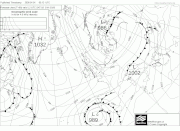
As above! Still looking at New Year for the peak of this cold spell and biggest risk for any snow. Its a bit like pulling teeth getting this mid Atlantic high to ridge far enough north west to get the colder uppers to the UK..the overnight gfs run just makes it to allow -10 uppers to move west over the UK..It currently looks a fine line between the UK tapping into this cold, unstable air from tje east or staying cold and dry whilst all the very cold air and snow heads for Greece and Italy!
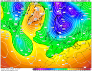
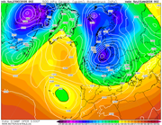
Good set of runs overnight. Dare I say it we are now seeing some potentially snowy outcomes as cold, unstable air moves south as our high finally migrates towards Greenland...also worth keeping an eye on the low to the south west as it tries to make inroads north...
UKMO 144:
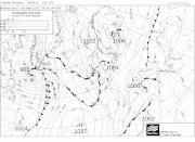
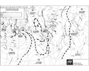
Saturday looking sweet spot for snow potential...fax charts not showing anything noteworthy in terms of little troughs in the northerly flow...yet. So as it stands coastal areas more likely to see some snow showers, mainly dry inland.
Almost a perfect straight northerly on Saturday, straight from the Arctic,...still no 'features' shown in the flow apart from one grazing the east coast , so as it stands, severe frosts, temps around zero degrees with a few snow showers around coasts.
The 'Pembrokeshire Dangler' has been introduced overnight. Western areas and particular the south west could do very well out of this weekend with a train of showers due to form and run through the same locations for up to 72 hours...
A very similar pattern to late november where we had a slight dusting from one shower where roads were closed 7 miles down the coast!
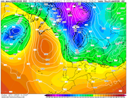
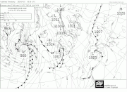
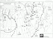
Fax for Tuesday certainly an interesting one especially for central and eastern areas as a developing low pushes fronts in from the west...probably rain in the west as Atlantic air mixes in with the residual cold, but turning to snow as it pushes inland...IF this chart verifies..
Frustratingly still seeing zero snow for me on the BBC / met "forecasts" (next 5 days). Seems to be the usual "dry and cold" or "wet but just warm enough to be rain". Shame.
I mean until this morning the GFS was throwing up some fantastic charts for Sunday and next week for us in the central south, but the 06z seems to have downgraded it all a touch, hope for snow nothing comes, hope for nothing then it’s a whiteout! I wish!
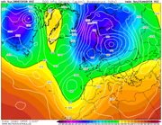
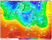
Latest fax for Tuesday, and you can see compared to the yesterdays for the same time period just how volatile the pattern is...the developing low now further west...good for maintaining the cold.. snow to rain event the likely outcome depending on progression eastwards..
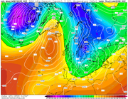
The next interest lies overnight Thursday into Friday. GFS has been showing this potential storm for some time, UKMO now has it. Expect gales heavy rain and even heavy snow on its northern edge, depending on track...
southamptonsnow2010 wrote: Mon Jan 05, 2026 11:34 am
Is this of any note? Tuesday/Wednesday time
Big call, but im going to say no away from the north east just due to the SW airflow which preceeds the fronts, in the south. Thursday / Friday, low could be interesting as the low is centered in the channel at the moment, so, easterly flow on the northern edge. Still an outside bet IMO.
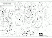
Track of Thursday night low shifted south compared to the chart posted yesterday...this one looks like bringing some fun and games..severe gales in its wake, rain, sleet and snow for southern and maybe central areas.