UKWeatherWatch is the UK’s leading weather forum – join fellow enthusiasts to discuss forecasts, charts, snow chances, heatwaves, and extreme weather events. Share updates and track storms together.
UKWeatherWatch is the UK’s leading weather forum – join fellow enthusiasts to discuss forecasts, charts, snow chances, heatwaves, and extreme weather events. Share updates and track storms together.
They are all moaning over on Netweather that one run of the ICON has sent the low further north without any further support (yet!) - quite meaty to read through and why I’ve flat out refused to join them! At least we all have our sensible heads on here, plus a surprise little feature for us southerners this morning!
KTtom wrote: Tue Jan 06, 2026 5:35 am
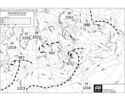
Track of Thursday night low shifted south compared to the chart posted yesterday...this one looks like bringing some fun and games..severe gales in its wake, rain, sleet and snow for southern and maybe central areas.
Looks like the MET have named it too! I've just had a warning for storm Goretti. Mustn't get excited... yet!
I dont think we're looking at widespread disruption due to snow at sea level...more hilly areas. There is still very cold air ahead of the low and also low dew points so, although the thickness level isnt as we would normally want and upper air temps are also higher than we would normally want, the intensity of the precipitation will result in rain turning to snow, especially overnight and on hills. Its actually the French met who named it , due to the severe gales likely on its southern flank.
Pains me to say it, but I fear you're right. The dam lines have both moved slightly north on the faxes in the last 12 hours.
Gav rated the Arpege model on his live snow watch steam earlier this evening. Any thoughts?
makelikeaturkey wrote: Tue Jan 06, 2026 9:07 pm
Gav rated the Arpege model on his live snow watch steam earlier this evening. Any thoughts?
Not really, it gets rolled out during snow events for some reason. There are so many model runs out there now its very easy to find a run showing what you want. I tend to stick to the main 3 and formulate a blend in my head as to likely scenario. Arpege only goes out short term so doesnt hold much interest for most.
Sadly alot of the Mets videos and text forecast seem to have been modelled on that ECM run Monday night...things have moved on since and the current trend is for quite a warm up next week...
I don't normally get involved with the forecasting side, I tend to leave that to the people that know what they are talking about, but I did notice that both gfs and ecm are forecasting a repeat of the strong winds for Cornwall this Friday (6th). What do you think?
Andee wrote: Fri Jan 09, 2026 9:20 pm
I don't normally get involved with the forecasting side, I tend to leave that to the people that know what they are talking about, but I did notice that both gfs and ecm are forecasting a repeat of the strong winds for Cornwall this Friday (6th). What do you think?
Sorry confused by the dates posted? 'This Friday (6th)' ? Do you mean Next Friday 16th?
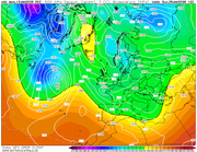
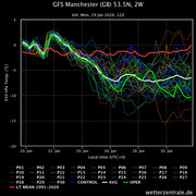
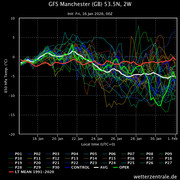
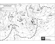
If indeed its next Friday, cant see anything really to worry about...gfs does have a low tracking in a very similar path as last weeks storm (below). Ukmo does not currently show this at 144. The difference with the gfs low is that it is formed over the cold Atlantic where as the storm was born over the Azores so even if it did materialise as shown it wont hve the energy of last weeks low. Having said all that, wet and often windy looks like being the way foreward for the next 10 days minimum.
Thanks Kev, I did mean the 16th. I’ve got so many dates flying around at the moment with the imminent move that I’m getting myself confused That’s good news if it isn’t going to have the energy, as so much damage has been done around Cornwall.
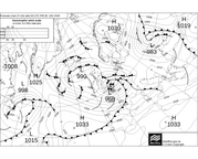
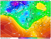
Back to 300 odd hours for our next chance of 'Winter' this time from the east! Other forums already getting into frenzy mode over this. We have been here before, most winters..verification rate probably 20% ... but here is the overnight gfs for +300 (interesting that ecm actually very similar)
One consistancy in the models is the lack of raging PV to the north...
A very fasinating period of model watching comming up. The Atlantic is forming an army out west ready to march east and the east european army is begining to form to the east intent on marching west..both look determined to have a battle somewhere over western europe. These set ups are often fluid down to relitively short timelines but should the battle occur over the UK there could be some 'proper' snowfall somewhere along the front line.
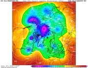
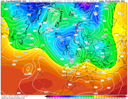
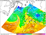
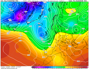
For whatever reason, and its above my knowledge threshold, the polor vortex just hasnt formed as you would expect this winter..normally you would expect a rounded ball of dark puples on a H500 chart centered over the pole and extending as far south as out lattitude. However, as you can see from thisngfs chart for the end of the month, its a disorganised mess..
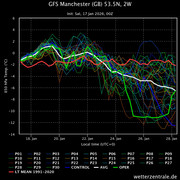
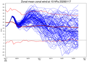
Looking at the zonal winds and we are currently avove average, although the trend is down from next week but no sign of a repeat SSW as of yet...
Maybe the Stratosphere is still feeling the effects of the December ssw or its just decoupled from the troposhere for a reason above my pay grade??


 That’s good news if it isn’t going to have the energy, as so much damage has been done around Cornwall.