UKWeatherWatch is the UK’s leading weather forum – join fellow enthusiasts to discuss forecasts, charts, snow chances, heatwaves, and extreme weather events. Share updates and track storms together.
UKWeatherWatch is the UK’s leading weather forum – join fellow enthusiasts to discuss forecasts, charts, snow chances, heatwaves, and extreme weather events. Share updates and track storms together.
KTtom wrote: Mon Jan 19, 2026 6:04 pm
ECM even chucks in a channel low for good measure for the snow starved south..
God I hope so, the last decent snowfall we had here in Seaford was 2013! Its crazy how rough we get it in the little gap between the downs.
When snow hits you can travel about 3 miles in any direction inland and see up to a foot of snow but the sea breeze gets funnelled through our little dip in the downs and seems to deliver us rain instead. I guess being at the slightly lower altitude (sea level) doesn't help either.
I miss the days when I was younger, you could almost guarantee at least 1 snow event every couple of years. Now the best we get is what looks like a really hard frost from a very light dusting.
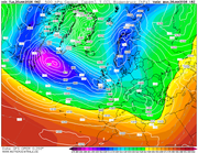
As often happens during periods like this, namely easterlies, things start to get a bit messey as we near 'the reliable' timeframe. Already little lows (shortwaves) are being shown up which scupper longevity of any continental flow shortening the severity of the cold. On the plus side, as opposed to a stale, dry, cold snap, this one does look primed for some widespread snow. Monday into Tuesday next week the sweet spot for the southern half of the UK as a deep Atlantic trough tries to make inroads from the south west..
Sorry, don't really know where to ask this, but isn't Exacta weather the one that always forecasts that it's going to be a really bad winter, every winter??
Genesis1977 wrote: Tue Jan 20, 2026 1:12 pm
Sorry, don't really know where to ask this, but isn't Exacta weather the one that always forecasts that it's going to be a really bad winter, every winter??
That'll be the one. As wheeled out by the Daily Excess every year. The only model they use is James Madden... and I'm assuming he's amazingly good looking because he's no weather model!
Any more discussion of either on this thread could result in us both getting kicked out!
Those who have followed the models over the years will know how difficult getting a potent easterly to our shores is. The famous ones, 1987, 2013, 2018 demonstate the point. Sadly, next weeks is being watered down daily now as we head towards the reliable timeframe...Sunday probably the coldest day as we pick up an easterly flow, but currently the Atlantic army looks like winning the battle next week..no doubt some will see some transient snow in the process.
Eyes firmly on the Strat now for a last chance of a meaningful cold spell in Feb....then Ill be longing for Spring!
Surprised there are no weather warnings out for Tomorrow and into the weekend as models have been showing a stormy period for the south west for a few days now due to an intense low stallling to the south west...
Sadly were back to looking out for Storms and flooding for weather headlines. Next weekend sums it up nicely, Atlantic lows just to strong for any easterly flow to make it to our shores, the issue then is the Atlantic lows stall over the UK and then only slowly fill. By the time this one burns itself out there is another leaving the US waiting to take its place!
southamptonsnow2010 wrote: Sat Jan 24, 2026 7:48 pm
Tonight’s 12z output from the GFS is good, but alas I believe it may be an outlier?
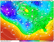
At the monent the Midlands north could be back in the equation sometime from next weekend as the jet tries to inch further south. Southern areas may have to wait a bit longer...mutterings about another SSW in 10 days or so forcing the vortex to split will no doubt lead to further fun and games on weather forums mid Feb.
We're stuck in a holding pattern for the foreseeable... or put it another way, No mans land! High pressure to the NE low very close to the SW..unsettled and coldish but not cold enough away from the far north east at times. Could do with the Atlantic lows to back off for a while to allow the colder air to move west under the high... seem to have been waiting on this for months now!
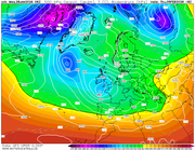
From above, this is the Mets forecast for the mid month period. Their video also talks of 'higher than normal confidence' in this outcome. This period on a personal note is the last chance of meaningful wintry spell, particularly for those in the southern half of the country.
UK long range weather forecast
Monday 2 Feb - Wednesday 11 Feb
This period will start off in a similar vein to current conditions. This means largely unsettled weather is expected, with showers or longer spells of rain for many places and occasionally rather windy. Some hill snow is likely in the north too. Temperatures will be close to average for most, but perhaps rather cold in the far northeast. A subtle change is now looking likely during the second half of this period, as the winds look like backing off to more of an easterly or north-easterly direction. It is likely to remain largely unsettled, especially towards the south, but it is likely to become colder with an increasing risk of snow, more particularly in the north. An often brisk wind will accentuate the colder feel too.
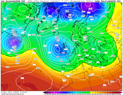
Very frustrating time at the moment...we have a window of opportunity for 2 weeks or so as the Atlantic stalls to allow some colder air to move south and west from the continent to the UK, but we just cant get rid of the low to our west diverting the cold north and keeping us wet!
If we have a hosepipe ban this summer my toys are going to get launched!
KTtom wrote: Sun Feb 01, 2026 6:02 am
Very frustrating time at the moment...we have a window of opportunity for 2 weeks or so as the Atlantic stalls to allow some colder air to move south and west from the continent to the UK, but we just cant get rid of the low to our west diverting the cold north and keeping us wet!
If we have a hosepipe ban this summer my toys are going to get launched!
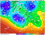
UKMO 144
This summer!?
Here in Sussex after all this rain, we still have a hosepipe ban from summer last year. It's an absolute joke!
SeafordSnow wrote: Sun Feb 01, 2026 11:06 pm
Here in Sussex after all this rain, we still have a hosepipe ban from summer last year. It's an absolute joke!
Blimey, that is a joke...has someone just forgotten its in force?
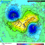
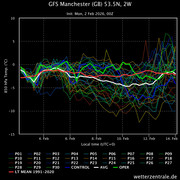
Temperature profile for Manchester still has about 50% of member in the magic zone -5 to -10 c between 8th and 12th. Im not getting a good feeling over this tho as it keeps getting shunted out.