UKWeatherWatch is the UK’s leading weather forum – join fellow enthusiasts to discuss forecasts, charts, snow chances, heatwaves, and extreme weather events. Share updates and track storms together.
UKWeatherWatch is the UK’s leading weather forum – join fellow enthusiasts to discuss forecasts, charts, snow chances, heatwaves, and extreme weather events. Share updates and track storms together.
KTtom wrote: Mon Feb 02, 2026 5:57 am
Im not getting a good feeling over this tho as it keeps getting shunted out.
As long as it doesn’t interfere with our imminent move to Cornwall, I’m not bothered
This moving house, is becoming a joke. We should have moved late Dec early Jan. Now it's looking like it could be early March. FFS, I need to get some fishing in.
daross wrote: Mon Feb 02, 2026 7:23 pm
I'm pretty tired of this dull weather we seem to have had for weeks now. I'd love some cold, crisp sunny winter days.
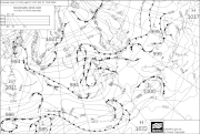
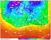
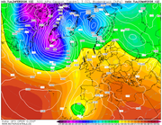
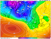
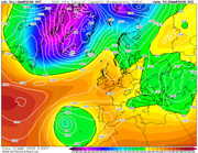
Very little change in sight going from latest output, fax for weekend sums up the pattern since Christmas ..the blocking high to the north east results in low pressure stationary to the south west with bands of rain and showers circulating anti clockwise around the core...
Met office 144, sums up the frustration...there is a screaming northerly on offer it the low would just move east of the UK, but no, it just sits there... more rain to come over the next 5 days.SSW lo9king unlikely now until late Feb, we need something to change the pattern. North east Scotland however, have had a cracking winter!
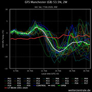
I think we can be confident of a cold Valentines weekend, however without a mid Atlantic ridge it doesnt look like lasting long. Some snow showers around coastal areas initially on Saturday, drier on Sunday then a risk of a snow to rain event on Monday.
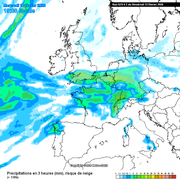
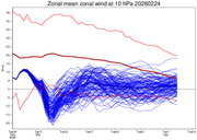
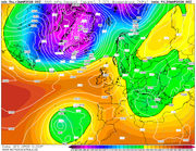
ECM for Saturday
Not a great deal of change really to my last post for the weekend..some sleet and snow following on from the rain as it pushes south on Friday, Dry, cold and sunny on Saturday! Then a reverse to Friday as sleet and snow pushes in from the west on Sunday turning quickly to rain in the south.
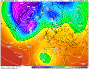
Another interesting development for mid week, both ukmo and gfs have a wedge of high pressure building to the north sending the next Atlantic low south, cold air drawn back in on its northern flank could give some snowfall for areas a bit further south than this weekends 'events'.
Staying fairly cold through the latter half of next week with further rain and hill snow, then a hint of a Mid Atlantic ridge curring off the endless Atlantic train of lows with a more prolonged dryer spell.
All aboard the south westerly express!
Winds will switch southwesterly for a few days, on thenplus side temperatures will rise to between 12 and 15 degrees for most, the negative is that it will be pretty gloomy. Later next week as the Jet moves south again, expect gales and rain to be the headline act once again...
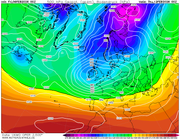
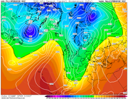
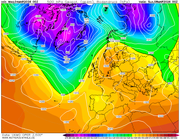
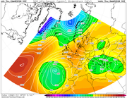
Finally, some signs of high pressure moving up over the country as we go through next week...gfs day 6 below.... A word of warning tho...a reversal in the Strat looks likely which could throw a spanner in the works for anyone wanting a warm start to spring..
Something not experienced for some considerable time....a fine, dry weekend..
Thursday looking a bit wet in the north and west and some rain possible Monday, otherwise looking very springlike....Met still not convinced the winter is over tho and still discussing a cold end to March so best not get the shorts out just yet!
KTtom wrote: Wed Mar 04, 2026 5:47 am
Something not experienced for some considerable time....a fine, dry weekend..
Thursday looking a bit wet in the north and west and some rain possible Monday, otherwise looking very springlike....Met still not convinced the winter is over tho and still discussing a cold end to March so best not get the shorts out just yet!
A dry weekend will be most welcome. We make our final trip down to Cornwall this weekend and the physical move complete. Looking forward to more sunshine in the months ahead. Sorry snow lovers.
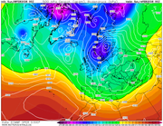
After a decent few days, with a couple more to come for the south eastern quadrant..the PV decides to get a bit close as we head towards next weekend, so rain, colder and windier the trend through next week .
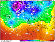
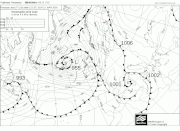
Fax chart for Sunday sums up the next week or so... Low pressure to the north west feeding bands of rain west to east on a brisk westerly wind. Follow the isobars back and you see they originate from a northerly direction, so temperatures tumbling enough for some snow on northern hills. The good news, the weather fronts move through quickly so some nice sunshine inbetween systems. Saturday the pick of the weekend.