
Autumn/Winter Model Outlook 2025/26
-
KTtom
- UKWW Admin
- Posts: 477
- Joined: Fri Oct 04, 2024 7:12 pm
- Has thanked: 119 times
- Been thanked: 568 times
Autumn/Winter Model Outlook 2025/26
This week will see a short northerly blast and tumbling temperatures from mid week after the latest Atlantic low exits east. Feeling cold and Autumnal for a couple of days, not a bad weekend, especially the further south and east you are before warmer southeasterly winds bring in sme fine weather next week courtesy of a euro high (subject to change  )
)
-
KTtom
- UKWW Admin
- Posts: 477
- Joined: Fri Oct 04, 2024 7:12 pm
- Has thanked: 119 times
- Been thanked: 568 times
Re: Autumn / Winter Model Outlook
Looming at upper air temps for next week, + 15 isotherm quite widely predicted being drawn up on a southerly wind. Had this set up occurred in July records would be in danger, as it is some areas will see greater than 10 degree increase in a few days with +20 likely.
-
KTtom
- UKWW Admin
- Posts: 477
- Joined: Fri Oct 04, 2024 7:12 pm
- Has thanked: 119 times
- Been thanked: 568 times
Re: Autumn / Winter Model Outlook
After the warmth, signs of an Atlantic storm for Sunday feeding off the warm air...some very strong winds for the north west in particular going by tonights ECM..
-
makelikeaturkey
- Posts: 72
- Joined: Sat Oct 05, 2024 5:05 pm
- Location: NG12
- Has thanked: 114 times
- Been thanked: 55 times
Re: Autumn / Winter Model Outlook
Anything in the longer range models to suggest a bit of snow this winter @KTtom?
-
KTtom
- UKWW Admin
- Posts: 477
- Joined: Fri Oct 04, 2024 7:12 pm
- Has thanked: 119 times
- Been thanked: 568 times
Re: Autumn / Winter Model Outlook
Nomakelikeaturkey wrote: Fri Oct 18, 2024 5:23 am Anything in the longer range models to suggest a bit of snow this winter @KTtom?
-
KTtom
- UKWW Admin
- Posts: 477
- Joined: Fri Oct 04, 2024 7:12 pm
- Has thanked: 119 times
- Been thanked: 568 times
Re: Autumn / Winter Model Outlook
KTtom wrote: Fri Oct 18, 2024 6:55 amNomakelikeaturkey wrote: Fri Oct 18, 2024 5:23 am Anything in the longer range models to suggest a bit of snow this winter @KTtom?
To be fair the models were full of promise last year and delivered diddly squat, hopefully this is a good omen! Most longer term models currently showing a possitive high pressure anomoly to the south last time I looked. Maybe have a bit of time for a good review this weekend as it looks like my Sunday golf will be blown away!
-
KTtom
- UKWW Admin
- Posts: 477
- Joined: Fri Oct 04, 2024 7:12 pm
- Has thanked: 119 times
- Been thanked: 568 times
Re: Autumn / Winter Model Outlook
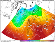
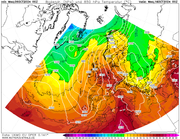
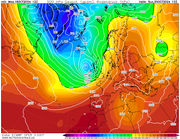
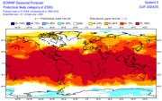
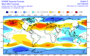
ECM seasonal for December to February (H500 pressure anomoly) indicates a pretty average winter pattern, lower pressure to the north west, higher pressure to the east indicating a south westerly flow for the UK. This is an average expected pattern over a 3 month period so doesnt rule out colder spells.
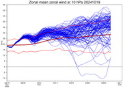
Mean zonal winds also showing a strengthening phase up to mid December indicating a zonal pattern for us...all long range and much like last year subject to change!
Strat winds
Mean Pressure
Mean zonal winds also showing a strengthening phase up to mid December indicating a zonal pattern for us...all long range and much like last year subject to change!
Strat winds
Mean Pressure
-
Andee

- UKWW Admin
- Posts: 508
- Joined: Thu Oct 03, 2024 4:21 pm
- Location: Mevagissey
- Has thanked: 263 times
- Been thanked: 145 times
Re: Autumn / Winter Model Outlook
Send me a link to the ecm charts Kev and I will look into it.
Keep up to date on our Facebook Group
https://www.facebook.com/groups/ukweatherwatch.co.uk
https://www.facebook.com/groups/ukweatherwatch.co.uk
-
KTtom
- UKWW Admin
- Posts: 477
- Joined: Fri Oct 04, 2024 7:12 pm
- Has thanked: 119 times
- Been thanked: 568 times
-
KTtom
- UKWW Admin
- Posts: 477
- Joined: Fri Oct 04, 2024 7:12 pm
- Has thanked: 119 times
- Been thanked: 568 times
Re: Autumn / Winter Model Outlook
A quiet week comming up,south westerly winds but no where near as strong as last weekend. Some rain associated with weak weather fronts as they move west to east especially later in the week. Staying warm with tomperatures mostly mid teens. As we head into next week, signs of it settling down as high pressure moves in to see us into November. So, winds falling away with mist and fog and cooler temperatures at night, still pleasant in the day.
-
KTtom
- UKWW Admin
- Posts: 477
- Joined: Fri Oct 04, 2024 7:12 pm
- Has thanked: 119 times
- Been thanked: 568 times
Re: Autumn / Winter Model Outlook
After a bit of a drab start to the week the promised high starts to take hold mid week onwards to bring a fairly lenghthy spell of quiet, dry weather with light winds. The million doller question at the moment is will it be a cloudy high of a sunny one..my punt at the moment is the former...chart for mid week...
-
KTtom
- UKWW Admin
- Posts: 477
- Joined: Fri Oct 04, 2024 7:12 pm
- Has thanked: 119 times
- Been thanked: 568 times
Re: Autumn / Winter Model Outlook
All dependant on how far north west the centre of the high is, yesterday, it was north west UK so was dragging in some colder air from the north east, today its more central uk so milder but cloudy. I thing the mid to high teens have gone for the foreseeable, temps nearer 10 c would be my guess from nextweekend .tidybrown wrote: Sun Oct 27, 2024 8:53 am Cheers KT - What about temps? Are we going to be dragging in some of that cold air to the north?
-
KTtom
- UKWW Admin
- Posts: 477
- Joined: Fri Oct 04, 2024 7:12 pm
- Has thanked: 119 times
- Been thanked: 568 times
Re: Autumn / Winter Model Outlook
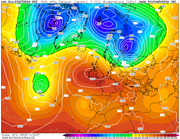
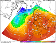
The Euro high which is beggining to develop now is absolutely relentless on the overnight runs, here is the last frame of the gfs, day 17 and its still in total control of our weather. So, expect a dry couple of weeks with light winds.. still a question mark regarding sunshine amounts and therefore frost and fog..
-
KTtom
- UKWW Admin
- Posts: 477
- Joined: Fri Oct 04, 2024 7:12 pm
- Has thanked: 119 times
- Been thanked: 568 times
Re: Autumn / Winter Model Outlook
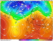
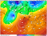
UKMO day 7...no words needed, europe, scandinavia and uk dominated by a massive area of high pressure, located on its western flank, we will remain very mild..
-
KTtom
- UKWW Admin
- Posts: 477
- Joined: Fri Oct 04, 2024 7:12 pm
- Has thanked: 119 times
- Been thanked: 568 times
Re: Autumn / Winter Model Outlook
Starting to get some confidence that the euro high will start to move westwards by this time next week, whilst it will initially not make too much difference to our weather, at least Scandinavia can start their winter!....stepping stones..
-
KTtom
- UKWW Admin
- Posts: 477
- Joined: Fri Oct 04, 2024 7:12 pm
- Has thanked: 119 times
- Been thanked: 568 times
Re: Autumn / Winter Model Outlook
Latest ECM pressure anomoly for the winter months is about as poor as it can get for cold, high pressure south west, low north = westerly flow...on the plus side, could be a dryer than average winter in the south.
-
KTtom
- UKWW Admin
- Posts: 477
- Joined: Fri Oct 04, 2024 7:12 pm
- Has thanked: 119 times
- Been thanked: 568 times
Re: Autumn / Winter Model Outlook
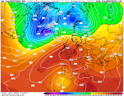
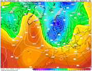
Gfs with its first day 12 tease of the season...a howling northerly...IF this were to verify some early snow likely for many... a bit extreme in my opinion, but signs are for a change from this stagnant mild weather is on the cards around mid month..
-
whiskey galore
- Posts: 17
- Joined: Sat Oct 26, 2024 6:24 pm
- Has thanked: 31 times
- Been thanked: 13 times
Re: Autumn / Winter Model Outlook
just need other models to come to do the same then we can think about putting heating on 
-
KTtom
- UKWW Admin
- Posts: 477
- Joined: Fri Oct 04, 2024 7:12 pm
- Has thanked: 119 times
- Been thanked: 568 times
Re: Autumn / Winter Model Outlook
Changes are afoot...finally!
Fax for early next week shows a weak front finally pushing through the country west to east, nothing extreme about that, but what it does do is allow cleaner colder air to follow. So remaining dry into next week but with temperatures down to single digits or just above but with some sunshine.
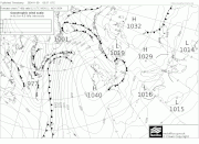
Models playing around with some sort of northerly blast for the end of the month...more later
Fax for early next week shows a weak front finally pushing through the country west to east, nothing extreme about that, but what it does do is allow cleaner colder air to follow. So remaining dry into next week but with temperatures down to single digits or just above but with some sunshine.
Models playing around with some sort of northerly blast for the end of the month...more later