
Warnings Issued — 2 YELLOW
Autumn/Winter Model Outlook 2025/26
-
whiskey galore
- Posts: 17
- Joined: Sat Oct 26, 2024 6:24 pm
- Has thanked: 31 times
- Been thanked: 13 times
Re: Autumn / Winter Model Outlook
looking good at the end of the run kev will let you post the gfs mid night run its going get cold.
-
KTtom
- UKWW Admin
- Posts: 477
- Joined: Fri Oct 04, 2024 7:12 pm
- Has thanked: 119 times
- Been thanked: 568 times
Re: Autumn / Winter Model Outlook
Yea, the gfs 'tease'I posted a few days ago is gaining traction, although still around ten days away there is agreement of a northerly of some sorts to see the month out..ecm also on board... It is still 10 days away and as we know, if it can go wrong.....whiskey galore wrote: Sat Nov 09, 2024 9:40 pm looking good at the end of the run kev will let you post the gfs mid night run its going get cold.
-
KTtom
- UKWW Admin
- Posts: 477
- Joined: Fri Oct 04, 2024 7:12 pm
- Has thanked: 119 times
- Been thanked: 568 times
Re: Autumn / Winter Model Outlook
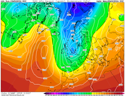
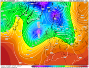
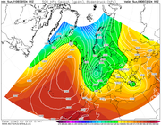
ECM showing the complexities going into next week..there isnt a nice clean northerly flow, instead little fronts form and cause waves in the flow. Some places probably will see snow while others will be cold and wet, obviously, so early in the season north with elevation is key.
-
makelikeaturkey
- Posts: 72
- Joined: Sat Oct 05, 2024 5:05 pm
- Location: NG12
- Has thanked: 114 times
- Been thanked: 55 times
-
KTtom
- UKWW Admin
- Posts: 477
- Joined: Fri Oct 04, 2024 7:12 pm
- Has thanked: 119 times
- Been thanked: 568 times
Re: Autumn / Winter Model Outlook
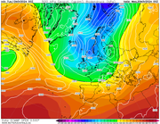
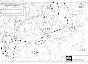
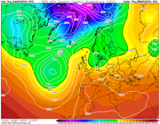
Disruption in the isobars (white lines), where they wabble or disrupt, or small circles indicate the pressence of small 'features' such as bands of showers or short waves (small lows).
-
KTtom
- UKWW Admin
- Posts: 477
- Joined: Fri Oct 04, 2024 7:12 pm
- Has thanked: 119 times
- Been thanked: 568 times
Re: Autumn / Winter Model Outlook
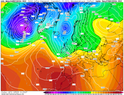
Met Office fax chart for Mid night Monday....anywhere on or up to 100 miles north of the low tracking west to east at risk of significant snow, south of the northernmost front and its rain.
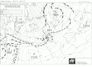
In the wake of the low is a stiff northerly which brings other coastal areas especially into the snow risk in the form of showers.
In the wake of the low is a stiff northerly which brings other coastal areas especially into the snow risk in the form of showers.
-
whiskey galore
- Posts: 17
- Joined: Sat Oct 26, 2024 6:24 pm
- Has thanked: 31 times
- Been thanked: 13 times
Re: Autumn / Winter Model Outlook
i see the 528 dam line leaving the south coast tuesday afternoon thats when any rain should turn to snow. if this is not correct can someone say please.
-
KTtom
- UKWW Admin
- Posts: 477
- Joined: Fri Oct 04, 2024 7:12 pm
- Has thanked: 119 times
- Been thanked: 568 times
Re: Autumn / Winter Model Outlook
Moving along from this weeks northerly, the next weather event looking likely to be next weekend as a very deep area of low pressure moves in from the west to effect most areas, some severe winds associated with it, so expect warnings and the Met to give it a name soon.
-
makelikeaturkey
- Posts: 72
- Joined: Sat Oct 05, 2024 5:05 pm
- Location: NG12
- Has thanked: 114 times
- Been thanked: 55 times
Re: Autumn / Winter Model Outlook
Looks like both the faxes, forecasts and warnings have moved slightly south over the course of the day. The METs risk matrix has increased the likelihood too.
Can't post images as I'm flying around at work.
Permission to get excited...?!
Can't post images as I'm flying around at work.
Permission to get excited...?!
-
Andee

- UKWW Admin
- Posts: 508
- Joined: Thu Oct 03, 2024 4:21 pm
- Location: Mevagissey
- Has thanked: 263 times
- Been thanked: 145 times
Re: Autumn / Winter Model Outlook
Permission grantedmakelikeaturkey wrote: Mon Nov 18, 2024 12:44 pm Looks like both the faxes, forecasts and warnings have moved slightly south over the course of the day. The METs risk matrix has increased the likelihood too.
Can't post images as I'm flying around at work.
Permission to get excited...?!
Keep up to date on our Facebook Group
https://www.facebook.com/groups/ukweatherwatch.co.uk
https://www.facebook.com/groups/ukweatherwatch.co.uk
-
KTtom
- UKWW Admin
- Posts: 477
- Joined: Fri Oct 04, 2024 7:12 pm
- Has thanked: 119 times
- Been thanked: 568 times
Re: Autumn / Winter Model Outlook
Latest fax for Thursday offering some hope for those in the south who may have missed out on yesterdays event as a chennel low skirts with southern areas..snow likely south of M4..
-
KTtom
- UKWW Admin
- Posts: 477
- Joined: Fri Oct 04, 2024 7:12 pm
- Has thanked: 119 times
- Been thanked: 568 times
Re: Autumn / Winter Model Outlook
Even though the centre of the storm is well to the north west of the country, Storm Bert still gives the uk a very wet and very windy day on Saturday, some transient, heavy snow for northern areas before temperatures rise dramatically through the day.
-
KTtom
- UKWW Admin
- Posts: 477
- Joined: Fri Oct 04, 2024 7:12 pm
- Has thanked: 119 times
- Been thanked: 568 times
Re: Autumn / Winter Model Outlook
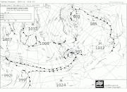
Mid week pressure chart shows high pressure trying to build over the UK.
In general, the week will be less cold than last week and much dryer than the weekend just gone. Mainly dry and cool, some sunshine, particularly mid week. Threat of some rain in the south east early in the week and again in the west later in the week as temperatures rise with the arrival of south westerlies.
Mid week:
-
KTtom
- UKWW Admin
- Posts: 477
- Joined: Fri Oct 04, 2024 7:12 pm
- Has thanked: 119 times
- Been thanked: 568 times
Re: Autumn / Winter Model Outlook
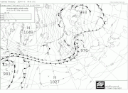
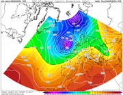
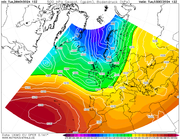
To add to my post about future snow chances. Even if deep prolonged cold is looking very unlikely for the next few weeks, UKMO day 7 is a good example of how if you can get the stars aligning you can still have a snowy surprise. Chart shows a shallow low heading south east over south western areas which coincides with a brief cold plunge from the north..IF this was to verify snow would be likely on its northern flank...something to keep an eye on maybe for next week.
-
KTtom
- UKWW Admin
- Posts: 477
- Joined: Fri Oct 04, 2024 7:12 pm
- Has thanked: 119 times
- Been thanked: 568 times
Re: Autumn / Winter Model Outlook
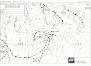
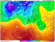
End of the week looks like potentially being a bit stormy again...most models have a small but deep low tracking over or close to the UK. In its wake, as shown by UKMO below the Azores high ridges north into the mid Atlantic with a north or north easterly flow for the weekend, se expect it turning colder again with wintry showers for some.
-
KTtom
- UKWW Admin
- Posts: 477
- Joined: Fri Oct 04, 2024 7:12 pm
- Has thanked: 119 times
- Been thanked: 568 times
Re: Autumn / Winter Model Outlook
Bit surprised the Met havent latched onto this vicious little low tracking through the country Friday Night. UKMO and GFS showing a period of severe gales even for inland areas. Perhaps as its overnight the Met dont think itll cause disruption?
-
whiskey galore
- Posts: 17
- Joined: Sat Oct 26, 2024 6:24 pm
- Has thanked: 31 times
- Been thanked: 13 times
Re: Autumn / Winter Model Outlook
that little low tracking east over the south could give some snow on its northen edge as it pulls colder air from the east 
-
KTtom
- UKWW Admin
- Posts: 477
- Joined: Fri Oct 04, 2024 7:12 pm
- Has thanked: 119 times
- Been thanked: 568 times
Re: Autumn / Winter Model Outlook
Yes, the met must have read my post and have now issued warnings for Friday through to Monday for a large part of England and Wales, also, as you say, they mention snow on its northern flankwhiskey galore wrote: Wed Dec 04, 2024 10:17 am that little low tracking east over the south could give some snow on its northen edge as it pulls colder air from the east