
Warnings Issued — 2 YELLOW
Autumn/Winter Model Outlook 2025/26
-
GarbageBags
- Posts: 86
- Joined: Wed Dec 04, 2024 3:54 pm
- Has thanked: 34 times
- Been thanked: 85 times
Re: Autumn / Winter Model Outlook
I've created a hype thread in model discussion so I don't go derailing proper model outlook with great single charts I see 3 weeks out 

-
GarbageBags
- Posts: 86
- Joined: Wed Dec 04, 2024 3:54 pm
- Has thanked: 34 times
- Been thanked: 85 times
Re: Autumn / Winter Model Outlook
Crazy how "unforecast" this is. Nothing indicative on the BBC weather app. This chart has the Isle of Man being sent to Kansas!
-
KTtom
- UKWW Admin
- Posts: 477
- Joined: Fri Oct 04, 2024 7:12 pm
- Has thanked: 119 times
- Been thanked: 568 times
Re: Autumn / Winter Model Outlook
Exactrly, for my area this is looking like the biggest storm for the last 20 years, yet warrents the same warning from the Met as a passing snow shower!GarbageBags wrote: Wed Dec 04, 2024 10:01 pm Crazy how "unforecast" this is. Nothing indicative on the BBC weather app. This chart has the Isle of Man being sent to Kansas!
-
makelikeaturkey
- Posts: 72
- Joined: Sat Oct 05, 2024 5:05 pm
- Location: NG12
- Has thanked: 114 times
- Been thanked: 55 times
Re: Autumn / Winter Model Outlook
The Met's matrix below still has it at the unlikely end.
https://weather.metoffice.gov.uk/warnin ... 0b58480cc1
Not very scientific, but the wind maps here will give an indication of what's happening... and they look pretty!
https://earth.nullschool.net/#current/w ... 867,66.812
Edit: Literally as I hit submit, it upgraded to a red for you Kev!
https://weather.metoffice.gov.uk/warnin ... 0b58480cc1
Not very scientific, but the wind maps here will give an indication of what's happening... and they look pretty!
https://earth.nullschool.net/#current/w ... 867,66.812
Edit: Literally as I hit submit, it upgraded to a red for you Kev!
-
KTtom
- UKWW Admin
- Posts: 477
- Joined: Fri Oct 04, 2024 7:12 pm
- Has thanked: 119 times
- Been thanked: 568 times
Re: Autumn / Winter Model Outlook
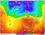
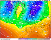
Not a particularly pretty picture heading into next week as the high pressure currently giving us a more seasonal feel sinks south as the Polor Vortex begins to establish itself to the north...milder with a north south split, wetter in the north, dryer in the south, and no storms ! 
-
GarbageBags
- Posts: 86
- Joined: Wed Dec 04, 2024 3:54 pm
- Has thanked: 34 times
- Been thanked: 85 times
Re: Autumn / Winter Model Outlook
"Classic" British weather in a chart right there.KTtom wrote: Tue Dec 10, 2024 6:46 am Not a particularly pretty picture heading into next week as the high pressure currently giving us a more seasonal feel sinks south as the Polor Vortex begins to establish itself to the north...milder with a north south split, wetter in the north, dryer in the south, and no storms !
-
KTtom
- UKWW Admin
- Posts: 477
- Joined: Fri Oct 04, 2024 7:12 pm
- Has thanked: 119 times
- Been thanked: 568 times
Re: Autumn / Winter Model Outlook
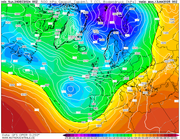
Not too much to get the juices flowing this week! Starting off mild, cloudy and fairly calm. Meed week see a deep low heading north to the west of the UK, nothing to suggest it will be worthy of a named storm but turning windy, especially to the north...turning colder later in the week as the low clears...
Mid week:
Mid week:
-
KTtom
- UKWW Admin
- Posts: 477
- Joined: Fri Oct 04, 2024 7:12 pm
- Has thanked: 119 times
- Been thanked: 568 times
Re: Autumn / Winter Model Outlook
I posted on the Hype charts thread a few days ago that the models were sniffing something out for the turn of the year which may be of interest to snow lovers...this continues to be the case as colder air is drawn south ... with low pressure systems also in the equation moving west to east where the 2 meet it could get interesting....not nailed on but gfs certainly been showing thisnfor a few days now..
-
KTtom
- UKWW Admin
- Posts: 477
- Joined: Fri Oct 04, 2024 7:12 pm
- Has thanked: 119 times
- Been thanked: 568 times
Re: Autumn / Winter Model Outlook
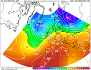
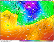
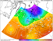
Models this morning upping the anti on the upcomming cold spell...GFS goes on to show the Holy Grail for a prolonged cold spell with a cut off Greenland high..IF this were to verify in 7 days or so, it not only draws the very cold air from Scandinavia west over the uk, it also opens the flood gates for low pressure to move in from the south bringing a threat of some Blizzard like conditions, gfs goes on to show this 'attack' on 3 seperate occassions after this chart...if we dont get the cut off high, expect cold and dry for a while..
Example of what may happen with a cut off Greenland high...BFTE
Example of what may happen with a cut off Greenland high...BFTE
-
KTtom
- UKWW Admin
- Posts: 477
- Joined: Fri Oct 04, 2024 7:12 pm
- Has thanked: 119 times
- Been thanked: 568 times
Re: Autumn / Winter Model Outlook
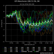
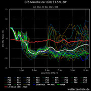
A quick look at temperature plots this morning, roughly 70% maintaining the cold for at least a week the others want to introduce milder air from the south west with a snow to rain event.
-
KTtom
- UKWW Admin
- Posts: 477
- Joined: Fri Oct 04, 2024 7:12 pm
- Has thanked: 119 times
- Been thanked: 568 times
Re: Autumn / Winter Model Outlook
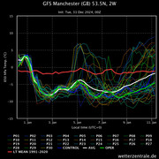
Not a great deal to add really this morning...gfs temperature plots now 80/20 in favour of a prolonged cold spell...its just a case now of trying to pick up where the snow risk is highest...south west in with a chance early next week as the first low tries in vein to make inroads to the cold block.
-
KTtom
- UKWW Admin
- Posts: 477
- Joined: Fri Oct 04, 2024 7:12 pm
- Has thanked: 119 times
- Been thanked: 568 times
Re: Autumn / Winter Model Outlook
Starting to look very interesting, even four southern areas on Sunday as fronts try to move north into the cold air. A real possibility of some areas having several hours of snow depending on how far north the fronts can get..Fax charts will make compulsive viewing over the next couple of days.
-
KTtom
- UKWW Admin
- Posts: 477
- Joined: Fri Oct 04, 2024 7:12 pm
- Has thanked: 119 times
- Been thanked: 568 times
Re: Autumn / Winter Model Outlook
I'll post in a bit more depth when I get to work, however, briefly, the low moves in a bit rapidly for the south, so only a temporary period of snow before turning to rain...the band of snow then stalls from a line north Wales eastwards before moving away Monday..expect Amber weather warnings for these areas.
-
KTtom
- UKWW Admin
- Posts: 477
- Joined: Fri Oct 04, 2024 7:12 pm
- Has thanked: 119 times
- Been thanked: 568 times
Re: Autumn / Winter Model Outlook
Fax chart shows the position of the front by mid-day Sunday. To the south of the front warmer air makes a brief appearance turning any snow to rain. On the line and to the north is the area where disruptive snow can be expected. This feature seems to be fairly stable in terms of location so don't expect too much movement in the area of snow/rain. Southern areas could still see a brief period of snow Saturday evening.
-
makelikeaturkey
- Posts: 72
- Joined: Sat Oct 05, 2024 5:05 pm
- Location: NG12
- Has thanked: 114 times
- Been thanked: 55 times
-
KTtom
- UKWW Admin
- Posts: 477
- Joined: Fri Oct 04, 2024 7:12 pm
- Has thanked: 119 times
- Been thanked: 568 times
Re: Autumn / Winter Model Outlook
Latest fax still has the sweet spot for north Wales, northern England mid day Sunday, these areas still likely to remain in the snow band before if moves off to the east..other areas still likely to see many hours of snow Saturday night before it turns to rain later..makelikeaturkey wrote: Thu Jan 02, 2025 6:02 pm Any chance of that rain not materialising? Or better still...!
-
makelikeaturkey
- Posts: 72
- Joined: Sat Oct 05, 2024 5:05 pm
- Location: NG12
- Has thanked: 114 times
- Been thanked: 55 times
Re: Autumn / Winter Model Outlook
When you've got a moment (as I'm guessing you're at work!) could you try explaining the implications of the warm (semi circles), cold (triangles) and occluded (both) fronts on the fax?
I know an occluded front is where the cold front has caught up with the warm front and pushed it higher, and I'm guessing that the consequent drop in temperature leads to precipitation... snow when it's cold enough?
The next fax suggests the cold front will continue catching up as they move north so I'm guessing that's the overnight snow.
But where the two fronts haven't met - will that just be rain from on the warm front?
And then there's another occluded front forecast to move east across the whole country on Monday night and Tuesday. Any chance of snow with that? Or is that where the dashed dam (or damn dashed?!) lines come in? I vaguely remember the 528 line being important? Or was it the 546?! Help... and thanks in advance because I know you'll help!