Page 6 of 12
Re: Autumn / Winter Model Outlook
Posted: Wed Sep 17, 2025 6:25 am
by KTtom
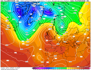
GFS model also going for a blocked last week of September. High pressure centered over Scandinavia feeding easterly winds over the UK...not particularly cold at this time of year, but dry, sunny and cool will feel like Autumn.
The mean pressure chart from all the model runs also shows high pressure dominant for the period mentioned so this scenario has high confidence of verification.
Re: Autumn / Winter Model Outlook
Posted: Wed Sep 24, 2025 6:16 am
by KTtom
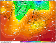
After a blip on Saturday (typical!), it looks like the continental high will cling on for most of next week also, maybe an exception in the far north west as south westerlies push in from the Atlantic, generally, dry, warm for late September, sunny but with cooler nights. Light rain the exception Saturday pushing east through the day. UKMO mid week chart..
Re: Autumn / Winter Model Outlook
Posted: Sun Sep 28, 2025 6:56 am
by KTtom
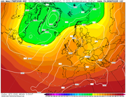
Early warning, next weekend could be quite windy as ex tropical storm 'Humberto' approaches from the Atlantic. The track of these storms notoriously difficult to predict so its no surprise the Met arent really getting exited about it...yet... here is mid week showing thenstorm heading towards Scotland.
Re: Autumn / Winter Model Outlook
Posted: Thu Oct 02, 2025 6:56 pm
by KTtom
Weather seems to be stuck in one of those annoying cycles where the wind and rain arrives on Saturday only to give way to a settled week..this weekend looks similar, however next weekend is currently looking good as high pressure builds in later next week and looks to hang around...some way off but currently looking like this stormy spell will just be a blip and not a pattern change.
Re: Autumn / Winter Model Outlook
Posted: Tue Oct 07, 2025 6:05 am
by KTtom
High pressure certainly gaining control of our weather for the next 10 days or so. By the weekend winds will be vertually non existent. However, the high is looking like it will be a 'cloudy high' so with no wind we could be looking at several gloomy days with mist and fog.
Re: Autumn / Winter Model Outlook
Posted: Thu Oct 09, 2025 5:47 am
by KTtom
Fast foreward to the middle of next week and high pressure still rock solid in charge....
Re: Autumn / Winter Model Outlook
Posted: Thu Oct 09, 2025 6:14 am
by makelikeaturkey
High pressure in the summer is generally warm. In the winter, it's generally cold. When will it shift from one to the other?!
Re: Autumn / Winter Model Outlook
Posted: Thu Oct 09, 2025 7:25 pm
by KTtom
makelikeaturkey wrote: Thu Oct 09, 2025 6:14 am
High pressure in the summer is generally warm. In the winter, it's generally cold. When will it shift from one to the other?!
Tends to be when the continent gets cold as the wid circulates clockwise around a high so the air over the uk tends to be cold and dry sourced from the east in Winter and hot and dry in Summer.
Re: Autumn / Winter Model Outlook
Posted: Fri Oct 10, 2025 6:23 am
by makelikeaturkey
KTtom wrote: Thu Oct 09, 2025 7:25 pm
makelikeaturkey wrote: Thu Oct 09, 2025 6:14 am
High pressure in the summer is generally warm. In the winter, it's generally cold. When will it shift from one to the other?!
Tends to be when the continent gets cold as the wid circulates clockwise around a high so the air over the uk tends to be cold and dry sourced from the east in Winter and hot and dry in Summer.
So when does the contingent get cold?!

Re: Autumn / Winter Model Outlook
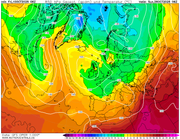
Posted: Fri Oct 10, 2025 12:19 pm
by KTtom
Depends!

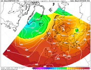
Looking at the 850 Hpa temperature for a week today (below), you can see we still have warm air over the UK but the continent is cooling rapidly. High pressure over or to the north of the UK will draw this colder air westwards. If a high is located to the south of the UK it will draw in mild Atlantic air. Definitely a delay this year, as was last year... Finland is often under snow cover mid October last year it was nearly December, this year Ruka looking good for snow shortly after 20th October.
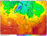
... a week later..
Re: Autumn / Winter Model Outlook
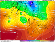
Posted: Mon Oct 13, 2025 7:48 pm
by KTtom
If you're a little bored with this benign weather, it looks like the pattern will change during the second half of the weekend as Atlantic systems move in to bring wind and rain and a more mobile pattern for the following week. Also worth noting how Scandinavia is due its first cold blast of Autumn..
UKMO for Sunday:
Re: Autumn / Winter Model Outlook
Posted: Tue Oct 14, 2025 1:52 pm
by Looosy
Saw my first silly snow headline today, with the tabloids going for 3-4 inches next week. Must be a slow news day. Looks like nothing more than a flurry in the Highlands to my novice eye?
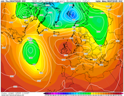
Re: Autumn / Winter Model Outlook
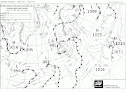
Posted: Thu Oct 16, 2025 5:45 am
by KTtom
Fax chart for Monday , pattern has flipped on its head. Whilst we're used to high pressure sat on top of the UK we now have a deep low, with further systems waiting in the wings to the south west for the rest of the week...I hear some places still officially in drought...thats about to change!
Re: Autumn / Winter Model Outlook
Posted: Sun Oct 19, 2025 7:07 am
by KTtom
Next Saturday looking cold and windy with a potent northerly. Rough sees around the coasts and snow showers for the Scottish mountains.
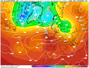
Re: Autumn / Winter Model Outlook
Posted: Tue Oct 21, 2025 5:59 pm
by KTtom
Thursday mid-day and a deepening low running west to east over southern areas, a rare event in that the strongest winds may be reserved for the southneast as it exits the UK
Re: Autumn / Winter Model Outlook
Posted: Sat Oct 25, 2025 10:02 am
by Genesis1977
Morning all. Long time lurker here. Not sure where to put this question. I like seeing the ice coverage that someone puts on here. Is there somewhere I can find it without being reliant on you helpful lot. Cheers.
Re: Autumn / Winter Model Outlook
Posted: Sat Oct 25, 2025 7:19 pm
by Andee
Here you go
https://www.ukweatherwatch.co.uk/viewtopic.php?t=771 once you click on the link you should see a spanner at the top. Click on this then you can subscribe to the topic.
Re: Autumn / Winter Model Outlook
Posted: Sat Oct 25, 2025 10:25 pm
by Genesis1977
Thanks for that, it looks like I am already subscribed. I also wondered where people get the Info from.
Re: Autumn / Winter Model Outlook
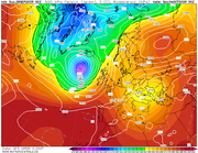
Posted: Sun Oct 26, 2025 6:40 am
by KTtom
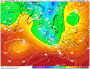
Unsettled wet and windy conditions continue for the next 7 to 10 days minimum. Pressure chart for end of week has a series of lows circlating around Ireland throwing bands of rain and showers over the UK...looks like being a wet Halloween in the west.
Re: Autumn / Winter Model Outlook
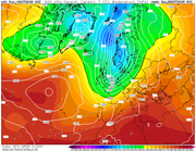
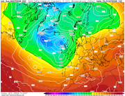
Posted: Tue Oct 28, 2025 5:59 pm
by KTtom
A hint for the future....
Day 10