Page 4 of 12
Re: Autumn / Winter Model Outlook
Posted: Fri Jan 03, 2025 10:45 am
by KTtom
Hi Makelikeaturkey...
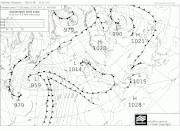
There are 2 main ingredients needed when it comes to snow. Firstly, the upper air temperatures in the troposphere need to be around -5 or below at 850hpa level. Particularly important when the air is moist i.e. tracks over the sea as opposed to being sourced from the continent when upper air temps can be a bit higher.
The second is the thickness lines you mentioned, these need to be as close to 528 dam or below. It is 546 or above forget it! 510 is the holy grail for the UK.
So, the fax shows a warm front heading north across the line north Wales eastwards , the precipitation can be up to 100 miles ahead of the front, this will be all snow. As the warm front clears, warm air is introduced at 850 hpa level rising above the residual cold air, so although the temperature on the ground will still be very cold, the higher air temperatures rise around cloud level, this is where you get freezing rain as the clouds produce rain which freezes as it hits ground level. As the warm front clears the warmer air replaces the cold surface air and it’s just plain rain.
The cold front introduces colder air and pushes the warmer uppers away, however, if the 2 ingredients mentioned above are not in place it will still be rain.
Your definition of occluded front is correct, however as neither of the 2 ingredients mentioned at the start are in place it will just be rain on Monday.
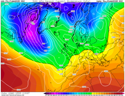
You can see from this 850hpa chart for mid-day Sunday how the warm uppers follow the warm front even though ground temperatures will still be very cold in northern areas.
Bit rushed, you are correct, I'm in work

Re: Autumn / Winter Model Outlook
Posted: Fri Jan 03, 2025 7:49 pm
by KTtom
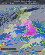
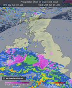
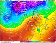
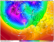
Latest UKV
8pm Sat
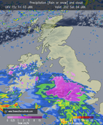
6am Sun
Re: Autumn / Winter Model Outlook
Posted: Fri Jan 03, 2025 8:11 pm
by Andee
Thanks Kev
Re: Autumn / Winter Model Outlook
Posted: Sat Jan 04, 2025 6:59 am
by KTtom
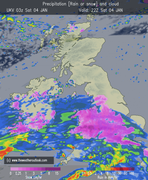
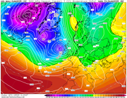
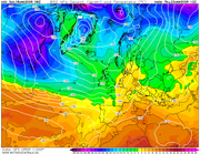
Same timeframe from this morning's run...
8pm tonight,
6am Sunday,
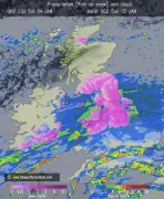
Slight delay by an hour or so....here is the 10pm chart, which seems to be the sweet spot for most of England and Wales..
Re: Autumn / Winter Model Outlook
Posted: Sat Jan 04, 2025 7:06 am
by KTtom
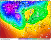
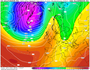
Longer term, expecting to see alot of this for the remainder of the month...mid lattitude high pressure, fine, crisp and dry..a long way off what the long term models were forecasting for January..
Re: Autumn / Winter Model Outlook
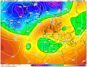
Posted: Sun Jan 05, 2025 7:07 pm
by KTtom
ECM day 10 showing the next point of interest, the chart above for next week shows a mid lattitude high, its then a case of where it decides to go, this chart shows probably the best scenario..a few other options on the table, but none showing a raging Atlantic.
Re: Autumn / Winter Model Outlook
Posted: Mon Jan 06, 2025 12:50 pm
by KTtom
A few interesting features affecting the UK over the next couple of days... firstly 3 or 4 troughs around the UK overnight bringing further sleet and snow showers..
Then on Wednesday a threat for the south. Although the fronts look to far south the 'weather' can be 100 miles or so before the exact location of the front, so southern counties definitely in the game for some snow.
Re: Autumn / Winter Model Outlook
Posted: Tue Jan 07, 2025 5:30 am
by KTtom
One final bit of drama before high pressure becomes the dominant factor..Friday sees a weakish front push in from the south west... uppers are a bit high for tis one but still low enough to bring some snow for inland areas, especially if you live up a hill. Mainly south west and southern areas currently favoured.
Re: Autumn / Winter Model Outlook
Posted: Thu Jan 09, 2025 7:07 am
by KTtom
Re: Autumn / Winter Model Outlook
Posted: Sun Jan 12, 2025 6:55 am
by KTtom
Solid support for high pressure to be in charge this week, staying cool in the south east but mild and cloudy elsewhere...its then a waiting game to see where the high moves to the following week....current indications its east allowing the Atlantic lows a chance to move in.
Re: Autumn / Winter Model Outlook
Posted: Mon Jan 13, 2025 7:55 pm
by KTtom
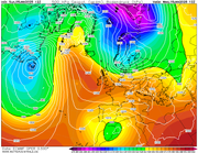
GFS longer range going for a Scandi high just as the polor vortex really gets organised to the north west. Scandi highs can be a prelude to a BFTE, however, if the angle of the high isnt right we more often than not end up on the wrong side of the battleground where Atlantic systems just stall over the UK, such as this chart, wild, wet and windy...we really dont want this to verify if you dont like storms.
Re: Autumn / Winter Model Outlook
Posted: Tue Jan 14, 2025 6:57 pm
by KTtom
Todays trend is for the vortex to hag back further west allowing the Scandi high to knock on the UK door from the east, even the Met mentioning a low chance of easterly winds by the end of next week...here is the ECM. These situations are notoriously hard to forecast and have often gone belly up at just t72hrs...
ECM
Re: Autumn / Winter Model Outlook
Posted: Fri Jan 17, 2025 5:59 am
by KTtom
Unfortunately the easterly looks pretty much dead in the water, models over estimating the ridge to the east. UKMO here has the ridge weaker but still strong enough to force the Atlantic lows on a NW / SE track towards the west , so still some potential for the time being of some wintry weather if the cold can get in before the troughs arrive.
Im off to Finland for a week, temps average about - 14 for the week, however snow depths significantly down on previous years, in fact tonight its raining at 3c

Re: Autumn / Winter Model Outlook
Posted: Fri Jan 17, 2025 7:14 pm
by KTtom
Next point of interest weatherwise is the back end of next week..all of the 'big 3' picking up on a storm heading directly towards the UK...the block to the north east, whilst now very unlikely to deliver snow or deep cold to the UK will decide where this storm tracks...currently Ireland gets a bashing before it moves north ...this will no doubt change but im going for a named storm this time next week...
Re: Autumn / Winter Model Outlook
Posted: Sat Jan 18, 2025 10:10 am
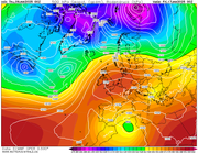
by KTtom
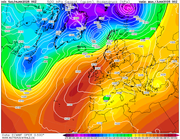
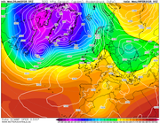
Some severe cold heading out from the Arctic into Canada and America, as this moves into the Atlantic it creates a massive temperature gradient as seen below..25c difference in uppers over a couple hundred miles...hence the risk of storms.
Re: Autumn / Winter Model Outlook
Posted: Mon Jan 27, 2025 7:38 am
by KTtom
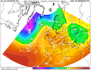
Looking at the 7 day mean of all gfs model runs, there is a strong signal for a euro high to build and settle things down again after a very stormy period. Unfortunately, we await the PV to retreat west of Greenland, until it does the chances of the Euro high ridging north into Scandinavia giving us a easterly blast are not favourable...
Re: Autumn / Winter Model Outlook
Posted: Wed Jan 29, 2025 6:43 am
by KTtom
We could be locked into this pattern for quite some time with two big players refusing to budge, the polor vortex to the NW and a strong Russian high to the east / north east. High pressure close to or over the UK is the best bet for the next 2 weeks which will be a welcome rest from Atlantic storms. Temps around average, coldest in the south east, milder and damp in the north west.
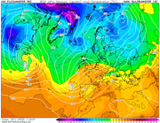
Re: Autumn / Winter Model Outlook
Posted: Thu Jan 30, 2025 6:37 am
by KTtom
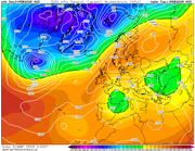
A nice UKMO chart for next week with high pressure sat over the UK. Dry, bright, light winds, a welcome break from the storms and floods we have endured recently.
Re: Autumn / Winter Model Outlook
Posted: Sat Feb 01, 2025 7:14 am
by KTtom
Models beggining to sniff out an easterly flow mid month as the high posted above migrates north east...plenty of uncertainty as to how potent this easterly will be, no signs of a BFTE yet but worth keeping an eye on...
ECM day 10
Re: Autumn / Winter Model Outlook
Posted: Sun Feb 02, 2025 6:54 am
by KTtom
Chances of an easterly slowly increasing...all 3 main players showing some sort of easterly, still improvements in the highs location needed for a snow event with more instability needed in the flow ...