Page 5 of 12
Re: Autumn / Winter Model Outlook
Posted: Mon Feb 03, 2025 6:18 am
by KTtom
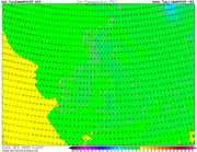
Looking at the temperature graphs, a significant drop off looking very likely. Period 8th to 12th has full spport for upper air temps to be below the -5 threshold. Just need to get some instability in the flow..
UKMO showing some unstable air moving into the south east, snow showers possible here...
Re: Autumn / Winter Model Outlook
Posted: Tue Feb 04, 2025 6:09 am
by KTtom
Dogs dinner!...15 degree spread after the weekend?
Re: Autumn / Winter Model Outlook
Posted: Wed Feb 05, 2025 5:57 am
by KTtom
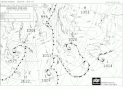
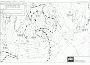
Fax picking up on a small low moving into the south east over the weekend...a mixture of rain sleet and maybe some light snow..frustrating that the continental air isnt as cold as it should be this time of year, it should have been an all snow feature..
Re: Autumn / Winter Model Outlook
Posted: Wed Feb 05, 2025 7:25 pm
by Looosy
SE just keeps missing out this winter

Re: Autumn / Winter Model Outlook
Posted: Thu Feb 06, 2025 6:16 am
by KTtom
Looosy wrote: Wed Feb 05, 2025 7:25 pm
SE just keeps missing out this winter
Unfortunately uppers just look too warm this weekend, likely to feel raw but rain and sleet mix the likely option.
Moving foreward, the consensus in the model world yesterday was to sink the high south later next week, however, overnight the Euro models have picked up on a new trend and send it north! This hasnthe potential of drawing the deep cold down its eastern flank towards the UK. Maybe easterly#2 will be more potent later in the month?
Re: Autumn / Winter Model Outlook
Posted: Sat Feb 08, 2025 6:44 am
by KTtom
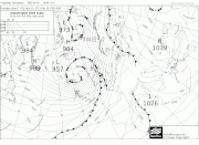
Others have followed the UKMO in moving the high north..some cracking charts on show for an east west battle next weekend....turning very cold in the east, Atlantic trying to encroach from the west...
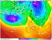
Re: Autumn / Winter Model Outlook
Posted: Mon Feb 10, 2025 7:41 pm
by KTtom
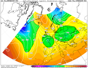
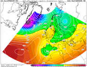
Still a wide range of options on the table for the weekend and into next week. Models keep playing with the idea of the very cold air to the east inching west...on the other hand, here is ECM with an early taste of Spring!
Re: Autumn / Winter Model Outlook
Posted: Tue Feb 11, 2025 6:08 am
by KTtom
UKMO now jumping on the spring bandwagon for next week... Personally, im ready for it, this last week or so has just been cold and misserable.
UKMO upper air temps should, if it verifies, give temperatures in double figures countrywide..
Re: Autumn / Winter Model Outlook
Posted: Thu Feb 13, 2025 7:13 am
by KTtom
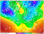
Full house now for the milder option next week with ecm finally on board...I think the term 'springlike' will be used fairly frequently over the next 10 days or so..
Ecm
Re: Autumn / Winter Model Outlook
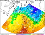
Posted: Fri Feb 14, 2025 6:23 am
by KTtom
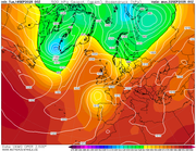
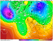
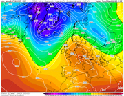
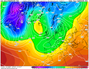
Upper air Temperatures profiles for the rest of the month...a massive flip over the last 48hrs...temps 15, 16 c by next weekend?

Re: Autumn / Winter Model Outlook
Posted: Fri Feb 14, 2025 3:22 pm
by Looosy
That's quite the flip! Here's hoping March can give us a final hurrah. Although I'm rather enjoying the sun today after it's long absence.
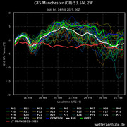
Re: Autumn / Winter Model Outlook
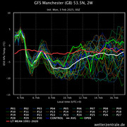
Posted: Sun Feb 16, 2025 7:00 am
by KTtom
GFS temperature profiles into March - Significant warm up this week by as much as 10 degrees compared to last week, then a drop off, probably indicating the Atlantic pushing in, then plenty of scatter as we pass the 10 day period ...
Re: Autumn / Winter Model Outlook
Posted: Tue Feb 18, 2025 7:28 am
by KTtom
Unfortunately we cant have mild temperatures, light winds and sunshine in Winter, as soon as the temps pick up, so the wind and rain arrives !!
Expecting a fairly wild day Friday and Sunday this week, especially in the west...temps in double figuresnthough to compensate...
Re: Autumn / Winter Model Outlook
Posted: Fri Feb 21, 2025 6:11 am
by KTtom
After a better day on Saturday with lighter winds and some sunshine, its rinse and repeat on Sunday as gales and heavy rain move in from the west once again....
Less windy next week and turning cooler.
Re: Autumn / Winter Model Outlook
Posted: Mon Feb 24, 2025 7:12 pm
by KTtom
Well, after the recent cold drab spell followed by the predicted unsettled wet and windy spell end of last week and over the weekend, ecm is going for a settled sunny and mild spell from later this week, will feel very springlike...
Next weekend:
...and through the following week..winds swing southerly..
Re: Autumn / Winter Model Outlook
Posted: Tue Feb 25, 2025 10:46 am
by Andee
I know we are all snow lovers, but I have to be honest I am looking forward to some sun now.
Re: Autumn / Winter Model Outlook
Posted: Thu Feb 27, 2025 7:37 pm
by KTtom
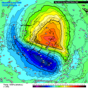
Just to rub salt in the wounds, a SSW is looking likely for week 1 March..far too late, given the lag effect on the Troposphere for a severe cold spell, but early enough to potentially give us a cold end to March and April, much like last year..when the PV shatters due to a SSW its still a case of hows your luck as to where the fragments of the Troposphere vortex get displaced to as to what the effects on our weather are...
This is what we want to see in Jan not March!
Re: Autumn / Winter Model Outlook
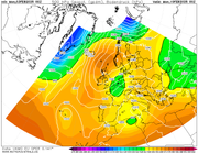
Posted: Mon Mar 03, 2025 6:08 am
by KTtom
Just to warn us against complacency, with this springlike weather.. gfs comes up with this set up for mid month...where was this in January!?
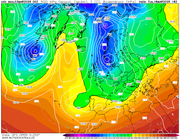
Whilst this evolution, at this timeframe is unlikely, what I do expect to see as we go through next week is high pressure to the north effecting our weather bringing cold easterly winds, so expect temperatures to plummet next week, especially for the north and east..
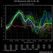
Re: Autumn / Winter Model Outlook
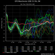
Posted: Tue Mar 04, 2025 5:49 am
by KTtom
Fine and dry with the warmest couple of days of the year this weekend. Temperatures widely nudging mid teens. A brisk south easterly wind Saturday, easing Sunday.
...then by next Tuesday, gfs has us 10 degrees colder!
Re: Autumn / Winter Model Outlook
Posted: Tue Sep 16, 2025 7:00 am
by KTtom
Models finally beggining to sniff out a pattern change, maybe as early as next week. UKMO showing high pressure building over or to the north of the UK bringing a rest bite from the unsettled wet and currently windy weather endured over the last 3 weeks or so.