Page 1 of 1
Christmas Countdown
Posted: Mon Dec 08, 2025 6:00 am
by KTtom
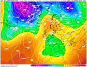
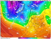
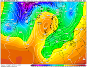
Not quite into range but here is gfs 1st attempt at Christmas Eve....
Actually, a cold, calm and dry day ahead as the AO slows due to the PV splitting with the UK sitting inbetween.
Lets see how things progress over the comming couple of weeks.
Re: Christmas Countdown
Posted: Wed Dec 10, 2025 6:22 am
by KTtom
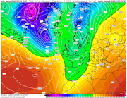
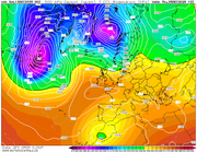
Gfs actually give us a brief northerly for the 25th courtesy of a ridging azores high...not super cold but some snow possible for Scotland..
Re: Christmas Countdown
Posted: Thu Dec 11, 2025 5:46 am
by KTtom
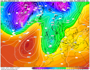
Dry but mild for most from this mornings offering away from the faf north...
Re: Christmas Countdown
Posted: Fri Dec 12, 2025 5:18 am
by KTtom
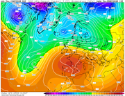
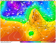
Ground hog day! A chart very similar to what were getting used to, low to the north west, high to the south east, mild, dry SE wetter the further NW you are..
Re: Christmas Countdown
Posted: Sat Dec 13, 2025 5:21 am
by KTtom
I get a feeling this will end up being close to the final outcome, high pressure centered just to the south...dry, average temps.
Re: Christmas Countdown
Posted: Sun Dec 14, 2025 5:43 am
by KTtom
Still trending for high pressure to be in charge

Re: Christmas Countdown
Posted: Tue Dec 16, 2025 5:16 am
by KTtom
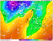
A colder set up with a brisk easterly wind developing for southern areas, maybe something wintry blowing in for the south east...
Re: Christmas Countdown
Posted: Wed Dec 17, 2025 6:48 am
by KTtom
ECM in range , similar to the gfs above, high pressure to the north, brisk easterly wind for the south, cold enough for some snow flurries over hills...
Re: Christmas Countdown
Posted: Sat Dec 20, 2025 6:47 am
by KTtom
Still 5 days away but unlikly to deviate much from this chart. A cold day, mostly dry, sunny spells in the north and west, a cold easterly wind in the south with maybe a few wintry showers for south and south easterly coasts.